1980s Maps of Graettinger, Iowa
Explore 2 historic maps of Graettinger from the 1980s. These maps offer a rare glimpse into what life looked like during the 1980s — showing old roads, neighborhoods, homes, and landmarks that have changed or disappeared over time.
Whether you're researching your family's past, planning a metal detecting trip, or studying how Graettinger's landscape evolved across the 1980s, these high-resolution maps are a powerful tool for exploring the history of this region.
- Focus on a specific era: All maps on this page are from the 1980s, giving you a focused view of this time period.
- See what’s changed: Compare century-old streets, trails, and buildings to today's modern landscape using overlays and satellite layers.
- Research with precision: Use these maps for genealogy, historical research, land use analysis, or educational projects.
- View, download, or print: Maps are fully viewable online in high resolution, and can be downloaded or printed for your own records.
Start exploring Graettinger's history through authentic maps from the 1980s. This is your window into the past.
Graettinger, IA maps
(2)- 1980 Map of Graettinger East
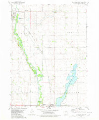 1980 Graettinger East1980 Print · USGSPalo Alto County in the early eighties shows a transition from traditional rail-side farming to modern conservation and education. Genealogists and historians can trace the Chicago Rock Island and Pacific tracks past Osgood and Valley View Cem.
 - 1985 Map of Estherville
 1985 Estherville1985 Print · USGSNorthern Iowa in the mid-eighties was a landscape of grid-patterned agriculture and vast marshland conservation. Genealogists can locate rural landmarks like Oak Hill Cemetery and Fourmile Lake School, or trace the rail lines of the Chicago and North Western.2 unique versions available
End of results
Showing maps 1-2 of 2
Top cities near Graettinger
- Estherville historical maps
- Emmetsburg historical maps
- Ruthven historical maps
- Terril historical maps
- Wallingford historical maps
- Ayrshire historical maps
See more
Frequently asked questions
- What are the different types of historical maps available for Graettinger?
- What is the oldest map of Graettinger?
- Where can I purchase historical maps of Graettinger for my home or office?
- Where can I download high-res historical maps of Graettinger?
- Are there historical topographic maps available for Graettinger?
- Is there historical aerial imagery available for Graettinger?
- Where are historical maps of Graettinger sourced from?