1960s Maps of Leando, Iowa
Explore 1 historic maps of Leando from the 1960s. These maps offer a rare glimpse into what life looked like during the 1960s — showing old roads, neighborhoods, homes, and landmarks that have changed or disappeared over time.
Whether you're researching your family's past, planning a metal detecting trip, or studying how Leando's landscape evolved across the 1960s, these high-resolution maps are a powerful tool for exploring the history of this region.
- Focus on a specific era: All maps on this page are from the 1960s, giving you a focused view of this time period.
- See what’s changed: Compare century-old streets, trails, and buildings to today's modern landscape using overlays and satellite layers.
- Research with precision: Use these maps for genealogy, historical research, land use analysis, or educational projects.
- View, download, or print: Maps are fully viewable online in high resolution, and can be downloaded or printed for your own records.
Start exploring Leando's history through authentic maps from the 1960s. This is your window into the past.
Leando, IA maps
(1)- 1965 Map of Douds, 1966 Print
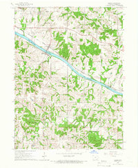 1965 Douds1966 Print · USGSDouds and Leando face each other across the Des Moines River in the mid-1960s, serving as a hub for both rail transit and local mining. Genealogists can locate several historic burial grounds and congregations, including White Chapel Cem, Zion Ch, and Valentine Cem.
End of results
Showing maps 1-1 of 1
Top cities near Leando
- Fairfield historical maps
- Keosauqua historical maps
- Eldon historical maps
- Agency historical maps
- Batavia historical maps
- Milton historical maps
See more
Frequently asked questions
- What are the different types of historical maps available for Leando?
- What is the oldest map of Leando?
- Where can I purchase historical maps of Leando for my home or office?
- Where can I download high-res historical maps of Leando?
- Are there historical topographic maps available for Leando?
- Is there historical aerial imagery available for Leando?
- Where are historical maps of Leando sourced from?