1980s Maps of Wapello County, Iowa
Explore 6 historic maps of Wapello County from the 1980s. These maps offer a rare glimpse into what life looked like during the 1980s — showing old roads, neighborhoods, homes, and landmarks that have changed or disappeared over time.
Whether you're researching your family's past, planning a metal detecting trip, or studying how Wapello County's landscape evolved across the 1980s, these high-resolution maps are a powerful tool for exploring the history of this region.
- Focus on a specific era: All maps on this page are from the 1980s, giving you a focused view of this time period.
- See what’s changed: Compare century-old streets, trails, and buildings to today's modern landscape using overlays and satellite layers.
- Research with precision: Use these maps for genealogy, historical research, land use analysis, or educational projects.
- View, download, or print: Maps are fully viewable online in high resolution, and can be downloaded or printed for your own records.
Start exploring Wapello County's history through authentic maps from the 1980s. This is your window into the past.
Wapello County, IA maps
(6)- 1980 Map of Fremont, 1981 Print
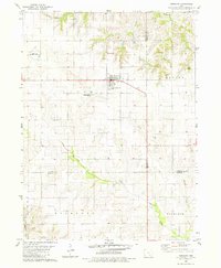 1980 Fremont1981 Print · USGSThe town of Fremont sits at a crossroads of three counties in the early 1980s, anchoring a landscape of precision-surveyed farmland and prairie creeks. Researchers can trace local heritage at Township Memorial Cem, Ford Cem, and the rural Helm Cem.
 - 1980 Map of Hedrick, 1981 Print
 1980 Hedrick1981 Print · USGSHedrick and the surrounding Keokuk County farmland are captured in the early eighties as the rail lines still shaped the local economy. Genealogists and local historians can trace numerous rural burial sites including Akerman Cem, Hook Cem, and Deuser Cem.
 - 1980 Map of Pekin, 1981 Print
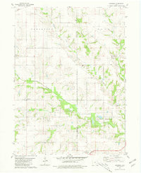
 1980 Pekin1981 Print · USGSSoutheast Iowa farming communities thrive at the meeting point of Keokuk, Jefferson, and Wapello counties during the late twentieth century. Researchers can trace rural life through landmarks like Van Orsdall Cem, the Pekin Community Sch, and the Old Railroad Grade.
 - 1980 Map of Abingdon, 1981 Print
 1980 Abingdon1981 Print · USGSSoutheast Iowa farming communities and township lines are preserved here during the late twentieth century. Researchers can trace ancestral roots through local landmarks like Walnut Hill Cem, the village of Abingdon, and the Batavia Peoples Ch.
 - 1981 Map of Centerville, 1982 Print
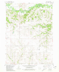
 1981 Centerville1982 Print · USGSThe borderlands of southern Iowa and northern Missouri are captured here in the early eighties as Rathbun Lake and the Chariton River define the local geography. Researchers can trace historic rail lines like the Norfolk and Western and locate vanished hamlets such as Coal City and Glenwood Junction.
 - 1982 Map of Oskaloosa
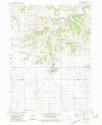
 1982 Oskaloosa1982 Print · USGSSoutheast Iowa's river valleys and rail hubs are meticulously detailed in the early eighties, showing a landscape of productive farmland and growing municipal centers. Researchers can trace the legacy of small-town life and local industry through features like Union Mills, What Cheer, and the extensive Burlington Northern rail network.
End of results
Showing maps 1-6 of 6
Top cities of Wapello County
- Ottumwa historical maps
- Eldon historical maps
- Agency historical maps
- Blakesburg historical maps
- Kirkville historical maps
- Chillicothe historical maps
Frequently asked questions
- What are the different types of historical maps available for Wapello County?
- What is the oldest map of Wapello County?
- Where can I purchase historical maps of Wapello County for my home or office?
- Where can I download high-res historical maps of Wapello County?
- Are there historical topographic maps available for Wapello County?
- Is there historical aerial imagery available for Wapello County?
- Where are historical maps of Wapello County sourced from?