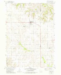
1980 Map of Fremont
USGS Topo · Published 1981About this map
Fremont stands at the intersection of Iowa Highway 149 and Highway 63, serving as a hub for the agricultural townships of Cedar, Benton, and Richland. This 1980 survey reveals a landscape where modern infrastructure like the Oskaloosa Municipal Airport and Sewage Disposal Ponds sits alongside established rural markers. The town is flanked by the Township Memorial Cem and Township Cem, while the surrounding countryside preserves smaller family and local burial grounds including Ford Cem and Helm Cem. The drainage patterns of Southeast Iowa are clearly defined here by the winding course of Cedar Creek and its many tributaries, such as Olive Branch, Spring Creek, and Mattix Br. The map also captures the complex political geography of the region, where the boundaries of Mahaska, Keokuk, and Wapello Counties converge near the flow of Mequonko Creek.
Find a feature on this map
22 named features on this map. Tap any name to fly to it.
Don’t see what you’re looking for? This feature index may not catch every label — zoom into the map to look around manually.
Map Details
Editions of this 1980 Fremont Map
This is the sole edition of this map. No revisions or reprints were ever made.
Other maps of this area

1954 · Des Moines
USGS Topo · 1:250,000

1956 · Des Moines
USGS Topo · 1:250,000

1956 · Farson
USGS Topo · 1:24,000

1956 · Ottumwa North
USGS Topo · 1:62,500

1956 · Ottumwa North
USGS Topo · 1:24,000

1957 · Des Moines
USGS Topo · 1:250,000

1965 · Rose Hill
USGS Topo · 1:24,000

1965 · Delta
USGS Topo · 1:24,000

1968 · University Park
USGS Topo · 1:24,000

1968 · Kirkville
USGS Topo · 1:24,000