1970s Maps of Washington County, Iowa
Explore 8 historic maps of Washington County from the 1970s. These maps offer a rare glimpse into what life looked like during the 1970s — showing old roads, neighborhoods, homes, and landmarks that have changed or disappeared over time.
Whether you're researching your family's past, planning a metal detecting trip, or studying how Washington County's landscape evolved across the 1970s, these high-resolution maps are a powerful tool for exploring the history of this region.
- Focus on a specific era: All maps on this page are from the 1970s, giving you a focused view of this time period.
- See what’s changed: Compare century-old streets, trails, and buildings to today's modern landscape using overlays and satellite layers.
- Research with precision: Use these maps for genealogy, historical research, land use analysis, or educational projects.
- View, download, or print: Maps are fully viewable online in high resolution, and can be downloaded or printed for your own records.
Start exploring Washington County's history through authentic maps from the 1970s. This is your window into the past.
Washington County, IA maps
(8)- 1970 Map of Cotter, 1972 Print
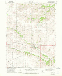
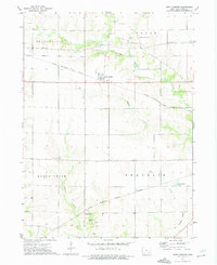
 1970 Cotter1972 Print · USGSLouisa County, Iowa, is captured in the early seventies, showing a landscape defined by the convergence of the Iowa River and major rail lines. Genealogists can locate several family burial sites like Bethel Cem and Boston Cem or trace the early town layouts of Cotter and Columbus City.
 - 1970 Map of Ainsworth, 1972 Print
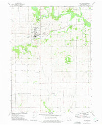
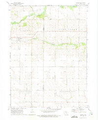
 1970 Ainsworth1972 Print · USGSSoutheast Iowa's rail-and-river network is frozen in time during the early seventies, showing a landscape defined by industrial transport and small-town roots. Researchers can locate family landmarks like Bethel Ch, trace the old Chicago Rock Island and Pacific line, or find Campground Cem.
 - 1973 Map of Wellman, 1975 Print
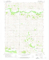
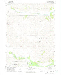
 1973 Wellman1975 Print · USGSEastern Iowa's agricultural heartland is documented here in the early seventies, centered on the river-fed plains of Washington County. Researchers can trace rural genealogy and land use through specific sites like Wassonville Cem, the village of Lexington, and the Wellman Municipal Airport.
 - 1973 Map of Amish, 1975 Print
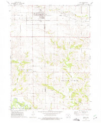
 1973 Amish1975 Print · USGSIowa's rural heritage is preserved in this mid-1970s survey of the Johnson and Washington county borders. Genealogists and local historians can trace the foundations of this community through the Mennonite Sch, Windham cemetery, and Amish settlement.
 - 1973 Map of Keota, 1975 Print
 1973 Keota1975 Print · USGSMid-century Iowa life is centered around the railroad town of Keota and the surrounding agricultural townships in the 1970s. Genealogists can trace several rural burial grounds like St Marys Cem and old settlements such as Talleyrand or the riverside Valley.
 - 1973 Map of West Chester, 1975 Print
 1973 West Chester1975 Print · USGSSoutheast Iowa farm country is captured here during the mid-seventies, showing the intersection of rail lines and rural townships. Researchers can locate several country cemeteries like Roberts Chapel Cem or trace the Old Railroad Grade near Grace Hill.
 - 1973 Map of Kinross, 1975 Print
 1973 Kinross1975 Print · USGSKinross and the surrounding Iowa farmsteads are shown in the 1970s, a period when local rail lines like the Central Iowa Transportation Coop still shaped the landscape. Researchers can locate family sites and rural landmarks, from St Patricks Cem to the small community of Nira.
 - 1973 Map of Holbrook, 1975 Print
 1973 Holbrook1975 Print · USGSIowa County farmland in the early 1970s reveals a quiet landscape shaped by the North English River and the legacy of local settlements. Genealogists can trace family roots through several rural burial grounds, including St Josephs Cem, Piersol Cem, and the community of Holbrook.
End of results
Showing maps 1-8 of 8
Top cities of Washington County
- Washington historical maps
- Kalona historical maps
- Wellman historical maps
- Riverside historical maps
- Brighton historical maps
- Ainsworth historical maps
See more
Frequently asked questions
- What are the different types of historical maps available for Washington County?
- What is the oldest map of Washington County?
- Where can I purchase historical maps of Washington County for my home or office?
- Where can I download high-res historical maps of Washington County?
- Are there historical topographic maps available for Washington County?
- Is there historical aerial imagery available for Washington County?
- Where are historical maps of Washington County sourced from?