1970s Maps of Seymour, Iowa
Explore 2 historic maps of Seymour from the 1970s. These maps offer a rare glimpse into what life looked like during the 1970s — showing old roads, neighborhoods, homes, and landmarks that have changed or disappeared over time.
Whether you're researching your family's past, planning a metal detecting trip, or studying how Seymour's landscape evolved across the 1970s, these high-resolution maps are a powerful tool for exploring the history of this region.
- Focus on a specific era: All maps on this page are from the 1970s, giving you a focused view of this time period.
- See what’s changed: Compare century-old streets, trails, and buildings to today's modern landscape using overlays and satellite layers.
- Research with precision: Use these maps for genealogy, historical research, land use analysis, or educational projects.
- View, download, or print: Maps are fully viewable online in high resolution, and can be downloaded or printed for your own records.
Start exploring Seymour's history through authentic maps from the 1970s. This is your window into the past.
Seymour, IA maps
(2)- 1979 Map of Seymour East, 1980 Print
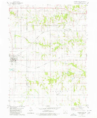 1979 Seymour East1980 Print · USGSThe borderlands of Wayne and Appanoose Counties are captured here in the late seventies, showing a landscape shaped by competing rail lines. Genealogists and local historians can locate several rural landmarks including Little Flock Chapel, Crossroads Cem, and the settlement of Jerome.
 - 1979 Map of Seymour West, 1980 Print
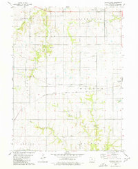 1979 Seymour West1980 Print · USGSWayne County agriculture and rail transportation intersect in the late 1970s near the settlements of Promise City and Seymour. Genealogists and historians can trace defunct routes like the Old RR Gr or locate family burial sites at Bollman Cem.
End of results
Showing maps 1-2 of 2
Top cities near Seymour
- Unionville historical maps
- Corydon historical maps
- Mystic historical maps
- Cincinnati historical maps
- Lucerne historical maps
- Promise City historical maps
See more
Frequently asked questions
- What are the different types of historical maps available for Seymour?
- What is the oldest map of Seymour?
- Where can I purchase historical maps of Seymour for my home or office?
- Where can I download high-res historical maps of Seymour?
- Are there historical topographic maps available for Seymour?
- Is there historical aerial imagery available for Seymour?
- Where are historical maps of Seymour sourced from?