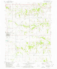
1979 Map of Seymour East
USGS Topo · Published 1980About this map
Seymour serves as the primary hub of this southern Iowa landscape, situated at the intersection of the Wayne Co Appanoose Co line. The town's infrastructure includes the City Reservoir and Sew Disp Ponds, indicating the municipal development of the late 1970s. The regional transit and agricultural economy are clearly defined by the parallel routes of the Chicago Milwaukee St Paul and Pacific and the Chicago Rock Island and Pacific railroads, which cross the terrain to connect the smaller settlement of Jerome to the broader corridor.
Find a feature on this map
27 named features on this map. Tap any name to fly to it.
Don’t see what you’re looking for? This feature index may not catch every label — zoom into the map to look around manually.
Map Details
Editions of this 1979 Seymour East Map
This is the sole edition of this map. No revisions or reprints were ever made.
Other maps of this area

1935 · Russell
USGS Topo · 1:62,500

1938 · Russell
USGS Topo · 1:62,500

1939 · Centerville
USGS Topo · 1:62,500

1939 · Mystic
USGS Topo · 1:62,500

1941 · Centerville
USGS Topo · 1:62,500

1942 · Mystic
USGS Topo · 1:62,500

1942 · Seymour
USGS Topo · 1:62,500

1944 · Seymour
USGS Topo · 1:62,500

1954 · Centerville
USGS Topo · 1:250,000

1957 · Centerville
USGS Topo · 1:250,000