Loading...
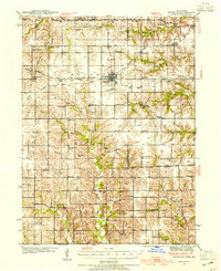
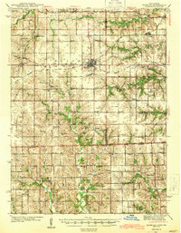
Loading map...1942 Map of Seymour
USGS Topo · Published 1954About this map
Seymour and Promise City serve as the primary hubs in this region of southern Iowa, surveyed between 1939 and 1942. The landscape is defined by a dense network of country schools and rural chapels, such as Brush College Sch and Bollman Chapel, reflecting the agricultural community structure of the era. The terrain is dissected by numerous waterways including Walnut Creek and Shoal Creek, which flow through various townships like Walnut, South, and Johns.
Find a feature on this map
80 named features on this map. Tap any name to fly to it.
Don’t see what you’re looking for? This feature index may not catch every label — zoom into the map to look around manually.
Map Details
Date Portrayed1942
Date Published1954
PublisherU.S. Geological Survey
Map TypeTopographic
Scale1:62,500
Physical Dimensions17 x 20.8 inches
Editions of this 1942 Seymour Map
This is the sole edition of this map. No revisions or reprints were ever made.
Historical Maps of Seymour Through Time
Featured Locations
Source Details
SourceU.S. Geological Survey
CopyrightPublic Domain