
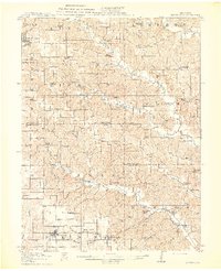
1914 Map of Green City
USGS Topo · Published 1914About this map
Unionville and Green City anchor this rural landscape just before World War I, where a dense network of one-room schoolhouses served an agricultural population. The terrain is defined by the branching tributaries of South Blackbird Creek, Spring Creek, and Mussel Fork, creating a series of ridges and hollows that shaped early settlement patterns. Along the southern edge, the Kansas City and Omaha railroad line connects the towns of Greencastle and Green City, facilitating the movement of local goods and livestock. Numerous named schools, such as Harlan School, Thompson School, and Port Arthur School, are spaced throughout the townships, reflecting the community structure of early 20th-century north-central Missouri. Local landmarks like Shibley Point and small hamlets like Stahl and Rosewood provide specific touchpoints for researchers tracing family ties to the Union and Richland areas during this period.
Find a feature on this map
64 named features on this map. Tap any name to fly to it.
Don’t see what you’re looking for? This feature index may not catch every label — zoom into the map to look around manually.
Map Details
Editions of this 1914 Green City Map
2 editions found
Other maps of this area

1911 · Queen City
USGS Topo · 1:62,500

1912 · Green City
USGS Topo · 1:62,500

1913 · Queen City
USGS Topo · 1:62,500

1938 · Kirksville
USGS Topo · 1:62,500

1939 · Centerville
USGS Topo · 1:62,500

1940 · Kirksville
USGS Topo · 1:62,500

1941 · Centerville
USGS Topo · 1:62,500

1942 · Seymour
USGS Topo · 1:62,500

1944 · Seymour
USGS Topo · 1:62,500

1954 · Centerville
USGS Topo · 1:250,000