1960s Maps of Garnett, Kansas
Explore 3 historic maps of Garnett from the 1960s. These maps offer a rare glimpse into what life looked like during the 1960s — showing old roads, neighborhoods, homes, and landmarks that have changed or disappeared over time.
Whether you're researching your family's past, planning a metal detecting trip, or studying how Garnett's landscape evolved across the 1960s, these high-resolution maps are a powerful tool for exploring the history of this region.
- Focus on a specific era: All maps on this page are from the 1960s, giving you a focused view of this time period.
- See what’s changed: Compare century-old streets, trails, and buildings to today's modern landscape using overlays and satellite layers.
- Research with precision: Use these maps for genealogy, historical research, land use analysis, or educational projects.
- View, download, or print: Maps are fully viewable online in high resolution, and can be downloaded or printed for your own records.
Start exploring Garnett's history through authentic maps from the 1960s. This is your window into the past.
Garnett, KS maps
(3)- 1961 Map of Lawrence
 1961 Lawrence1961 Print · USGSThe Kansas-Missouri borderland shows its mid-century transition from a rail-dependent agricultural region to a suburbanizing landscape. Genealogists can trace family footprints through numerous Cem sites and distinctive terrain landmarks like Graves Mound and Summers Mound.
 - 1966 Map of Garnett East, 1967 Print
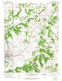 1966 Garnett East1967 Print · USGSAnderson County's rural character and the growth of its county seat are captured here in the mid-sixties. Genealogists and local historians can trace family locations near Scipio and Greeley, or locate legacy sites like Judy Sch and St John Cem.2 unique versions available
 - 1966 Map of Garnett West, 1967 Print
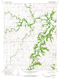 1966 Garnett West1967 Print · USGSAnderson County, Kansas, is captured here in the mid-1960s as a landscape of prairie agriculture and vital rail connections. Researchers can trace the Old Railroad Grade through Glenlock or locate family history at the Amish Cem and West Scipio Cem.2 unique versions available
End of results
Showing maps 1-3 of 3
Top cities near Garnett
- Richmond historical maps
- Centerville historical maps
- Colony historical maps
- Williamsburg historical maps
- Greeley historical maps
- Princeton historical maps
See more
Frequently asked questions
- What are the different types of historical maps available for Garnett?
- What is the oldest map of Garnett?
- Where can I purchase historical maps of Garnett for my home or office?
- Where can I download high-res historical maps of Garnett?
- Are there historical topographic maps available for Garnett?
- Is there historical aerial imagery available for Garnett?
- Where are historical maps of Garnett sourced from?