
Loading...
Loading map...1961 Map of Lawrence
USGS Topo · Published 1961About this map
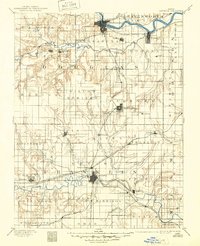
Military installations and a developing highway network define this mid-century landscape across the Kansas-Missouri border. The Sunflower Ordnance Works stands as a significant industrial landmark near Olathe, while regional defense is represented by Forbes AFB and Olathe NAS. The era of major water management is also visible, with the Clinton Reservoir noted as being under construction, alongside completed projects like the Pomona Reservoir.
Find a feature on this map
74 named features on this map. Tap any name to fly to it.
Don’t see what you’re looking for? This feature index may not catch every label — zoom into the map to look around manually.
Map Details
Date Portrayed1961
Date Published1961
PublisherU.S. Geological Survey
Map TypeTopographic
Scale1:250,000
Physical Dimensions30.32 x 21.8 inches
Editions of this 1961 Lawrence Map
This is the sole edition of this map. No revisions or reprints were ever made.
Historical Maps of Kansas City Through Time
7 maps found


Featured Locations
Source Details
SourceU.S. Geological Survey
CopyrightPublic Domain