1970s Maps of Barber County, Kansas
Explore 23 historic maps of Barber County from the 1970s. These maps offer a rare glimpse into what life looked like during the 1970s — showing old roads, neighborhoods, homes, and landmarks that have changed or disappeared over time.
Whether you're researching your family's past, planning a metal detecting trip, or studying how Barber County's landscape evolved across the 1970s, these high-resolution maps are a powerful tool for exploring the history of this region.
- Focus on a specific era: All maps on this page are from the 1970s, giving you a focused view of this time period.
- See what’s changed: Compare century-old streets, trails, and buildings to today's modern landscape using overlays and satellite layers.
- Research with precision: Use these maps for genealogy, historical research, land use analysis, or educational projects.
- View, download, or print: Maps are fully viewable online in high resolution, and can be downloaded or printed for your own records.
Start exploring Barber County's history through authentic maps from the 1970s. This is your window into the past.
Barber County, KS maps
(23)- 1970 Map of Freedom NE, 1972 Print
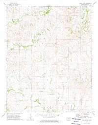
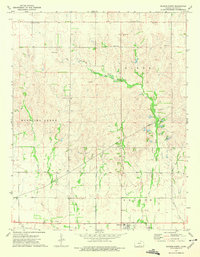
 1970 Freedom NE1972 Print · USGSThe Oklahoma-Kansas state line area in the early seventies shows a landscape of drainage creeks and rural industry. Researchers can trace the development of the plains via local landmarks like Yellowstone Creek, several Gas Wells, and the Landing Strip.
 - 1972 Map of Sharon South, 1975 Print
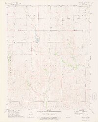
 1972 Sharon South1975 Print · USGSBarber County in the early 1970s shows a landscape where prairie agriculture meets the energy industry. Researchers can trace the Atchison Topeka and Santa Fe rails through Sharon or find family roots at Sharon Cem and Bethel Ch.
 - 1972 Map of Kiowa, 1975 Print
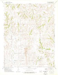
 1972 Kiowa1975 Print · USGSBarber County at the start of the 1970s shows a landscape defined by the Medicine Lodge River and major rail lines. Researchers can trace family history through Riverview Cemetery and locate historical landmarks like the Old Indian Treaty Boundary.
 - 1972 Map of Corwin, 1975 Print
 1972 Corwin1975 Print · USGSSouthern Kansas in the early 1970s is captured here at the intersection of rail history and the energy industry. Genealogists and historians can trace the Old Indian Treaty Boundary and explore local landmarks like Corwin and Hargis Lake.
 - 1972 Map of Crisfield, 1975 Print
 1972 Crisfield1975 Print · USGSThe rail-driven settlement of Crisfield and the southern Kansas prairie are captured here in the early 1970s. Trace the path of the Atchison Topeka and Santa Fe railroad alongside local landmarks like Crisfield Cem and Gravel Pits.
 - 1973 Map of Hardtner NW, 1975 Print
 1973 Hardtner NW1975 Print · USGSBarber County was a landscape of energy and faith in the early 1970s, as oil rigs operated alongside rural community centers. Genealogists and historians can locate Lodi Cem and Union Ch among the many sites of the Eagle Oil and Gas Field.
 - 1973 Map of Sun City NE, 1975 Print
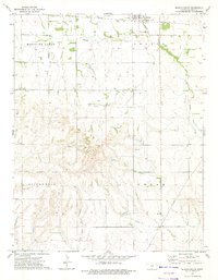
 1973 Sun City NE1975 Print · USGSBarber and Pratt Counties are captured here in the early 1970s, featuring the prominent Old Indian Treaty Boundary. Genealogists and historians can trace the course of Turkey Creek past Macadoo Dam and locate numerous mid-century Oil Wells.
 - 1973 Map of Isabel, 1975 Print
 1973 Isabel1975 Print · USGSIsabel and the surrounding Kansas prairie are captured here in the early seventies as the local rail-and-creek economy thrived. Genealogists and local historians can trace the Atchison Topeka and Santa Fe rail line, find Isabel Cem, and explore the banks of Lake Arrowhead.
 - 1973 Map of Pump Creek, 1975 Print
 1973 Pump Creek1975 Print · USGSBarber County ranch lands and energy production are captured here in the early seventies, showing a landscape defined by prairie creeks and petroleum extraction. Researchers can locate several Oil Wells, a private Landing Strip, and specific watercourses like Little Bear Creek and Deadman Creek.
 - 1973 Map of Deerhead, 1975 Print
 1973 Deerhead1975 Print · USGSBarber County's prairie landscape in the early seventies shows the intersection of ranching country and the energy industry. Researchers can trace the drainages of Mule Creek and Ash Creek or locate industrial sites like the Deerhead Oil Field.
 - 1973 Map of Lake City, 1975 Print
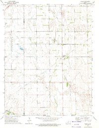
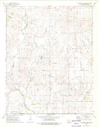
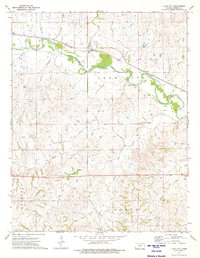 1973 Lake City1975 Print · USGSBarber County in the early 1970s is a landscape defined by its river valleys and energy production. Researchers can trace the rail corridor of the Atchison Topeka and Santa Fe through Lake City or locate the Deerhead Gas Field.
 - 1973 Map of Gerlane, 1975 Print
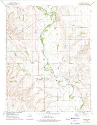 1973 Gerlane1975 Print · USGSBarber County in the early seventies is shown here as a landscape defined by its river valley and a robust petroleum industry. Researchers can trace the path of the Old Medicine Lodge Railroad Grade or find family history at Liberty Cem near Gerlane.
 - 1973 Map of Medicine Lodge, 1975 Print
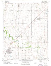
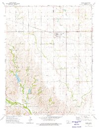
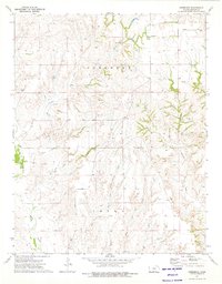
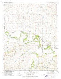
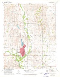 1973 Medicine Lodge1975 Print · USGSMedicine Lodge and the surrounding Barber County plains are captured in the early seventies, showcasing a thriving rail and oil landscape. Genealogists and historians can locate the Highland Cem, the community's Courthouse, and the tracks of the Atchison Topeka and Santa Fe.
 - 1973 Map of Sharon North, 1975 Print
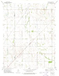
 1973 Sharon North1975 Print · USGSBarber County, Kansas, is captured here in the early 1970s, showcasing the agricultural and energy-driven character of the plains. Trace the local heritage of Sharon and locate family burial sites at Mumford Cem or St Boniface Cem near the A T & S F tracks.
 - 1973 Map of Hackberry Creek, 1975 Print
 1973 Hackberry Creek1975 Print · USGSBarber County, Kansas, is documented here in the early 1970s as a landscape defined by ranching, energy extraction, and ancient boundaries. Researchers can trace the Old Indian Treaty Boundary and locate early energy sites like the Gas Field and the rural settlement of Eldred.
 - 1973 Map of Medicine Lodge SW, 1975 Print
 1973 Medicine Lodge SW1975 Print · USGSBarber County's agricultural and industrial landscape is captured here in the early 1970s as the river valley economy thrives. Researchers can trace the Atchison Topeka and Santa Fe rail line through Mingona and locate the Cem near Forest City.
 - 1973 Map of Hardtner, 1975 Print
 1973 Hardtner1975 Print · USGSThe southern Kansas borderlands come into focus in the early 1970s, where the Old Indian Treaty Boundary meets the rail lines of the prairie. You can trace the local infrastructure of Hardtner, from its fairground to the Missouri Pacific railroad and the Elwood Oil and Gas Field.
 - 1973 Map of Zenda SE, 1975 Print
 1973 Zenda SE1975 Print · USGSSouthern Kansas in the early 1970s is shown as a busy landscape of energy extraction and rural homesteads. Trace the industrial footprint across Sharon Twp through its Oil and Gas Field, Compressor Station, and the quiet Baird Cem.
 - 1973 Map of Zenda, 1975 Print
 1973 Zenda1975 Print · USGSThe rural landscape around Zenda was a hub of energy and rail transit in the early 1970s. Researchers can trace the Old Indian Treaty Boundary and locate family history sites like St Johns Cem or the Pleasant Hill Cem.
 - 1973 Map of Nashville, 1975 Print
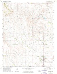
 1973 Nashville1975 Print · USGSNashville and the surrounding prairie were deeply connected to the rail and river systems in the early 1970s. Genealogists can trace family roots at Nashville Cem and St John Cem, or follow the historic Old Indian Treaty Boundary across the landscape.
 - 1973 Map of Sawyer, 1975 Print
 1973 Sawyer1975 Print · USGSSouthern Kansas prairie meets the energy industry in the 1970s as the rail line connects rural outposts. Genealogists and historians can trace the Old Indian Treaty Boundary and locate sites like Elm Mills, Sawyer, and the local Roadside Park.
 - 1973 Map of Stubbs, 1975 Print
 1973 Stubbs1975 Print · USGSThe Kansas-Oklahoma borderlands in the early seventies reveal a landscape of historical transitions and prairie commerce. Researchers can trace the Old Indian Treaty Boundary, the small community of Stubbs, and the defunct Old Railroad Grade.
 - 1973 Map of Aetna, 1975 Print
 1973 Aetna1975 Print · USGSThe Barber County ranching and energy country is captured here in the early seventies, centered on the settlement of Aetna. Researchers can trace the Old Indian Treaty Boundary and locate family plots at the Aetna Cem near the Salt Fork Arkansas River.
End of results
Showing maps 1-23 of 23
Top cities of Barber County
- Medicine Lodge historical maps
- Kiowa historical maps
- Sharon historical maps
- Hardtner historical maps
- Hazelton historical maps
- Isabel historical maps
See more
Frequently asked questions
- What are the different types of historical maps available for Barber County?
- What is the oldest map of Barber County?
- Where can I purchase historical maps of Barber County for my home or office?
- Where can I download high-res historical maps of Barber County?
- Are there historical topographic maps available for Barber County?
- Is there historical aerial imagery available for Barber County?
- Where are historical maps of Barber County sourced from?