1980s Maps of Butler County, Kansas
Explore 7 historic maps of Butler County from the 1980s. These maps offer a rare glimpse into what life looked like during the 1980s — showing old roads, neighborhoods, homes, and landmarks that have changed or disappeared over time.
Whether you're researching your family's past, planning a metal detecting trip, or studying how Butler County's landscape evolved across the 1980s, these high-resolution maps are a powerful tool for exploring the history of this region.
- Focus on a specific era: All maps on this page are from the 1980s, giving you a focused view of this time period.
- See what’s changed: Compare century-old streets, trails, and buildings to today's modern landscape using overlays and satellite layers.
- Research with precision: Use these maps for genealogy, historical research, land use analysis, or educational projects.
- View, download, or print: Maps are fully viewable online in high resolution, and can be downloaded or printed for your own records.
Start exploring Butler County's history through authentic maps from the 1980s. This is your window into the past.
Butler County, KS maps
(7)- 1985 Map of Emporia
 1985 Emporia1985 Print · USGSThe Flint Hills of central Kansas appear in high detail during the 1980s, centering on the convergence of the Cottonwood and Neosho rivers. Researchers can trace the Old Indian Treaty Boundary or locate prairie outposts like Matfield Green, Saffordville, and Bazaar.2 unique versions available
 - 1985 Map of El Dorado
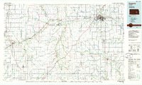
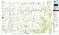
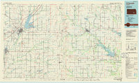 1985 El Dorado1985 Print · USGSThe Flint Hills region of Kansas was a hub of energy and rail transit in the mid-eighties, anchored by the expansion of El Dorado Lake. Researchers can trace the Indian Treaty Boundary and locate small communities like Sallyards, Pickrell Corner, and Oil Hill.
 - 1985 Map of Wichita
 1985 Wichita1985 Print · USGSThe mid-1980s landscape of the Wichita metro area is captured here during a peak era for the local aviation industry. Researchers can trace the sprawling rail network of the Santa Fe and Frisco or locate family landmarks at White Chapel Cem and Cheney Reservoir.
 - 1985 Map of Hutchinson
 1985 Hutchinson1985 Print · USGSCentral Kansas in the mid-1980s is revealed here as a landscape of productive plains, rail corridors, and growing college towns. Genealogists and historians can trace family plots at McPherson Cemetery and follow the routes of the Missouri Pacific through settlements like Moundridge and Hesston.2 unique versions available
 - 1985 Map of Sedan
 1985 Sedan1985 Print · USGSSoutheast Kansas in the mid-1980s is defined by rail towns and prairie waterways along the Chautauqua and Cowley county lines. Researchers can trace the Atchison Topeka and Santa Fe line through Grenola or locate the Indian Treaty Boundary and Kaw State Wildlife Area.2 unique versions available
 - 1985 Map of Wellington
 1985 Wellington1985 Print · USGSSouthern Kansas in the mid-eighties reveals a landscape shaped by historical lines and rail commerce, from Wellington to the Arkansas River. Researchers can trace the Old Indian Treaty Boundary and locate family sites near Prairie Lawn Cem or Bluff City.2 unique versions available
 - 1989 Map of Elbing, 1990 Print
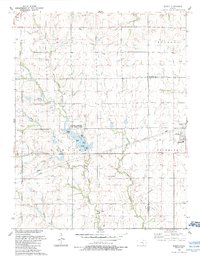 1989 Elbing1990 Print · USGSElbing and Walton are documented here in the late eighties, showing a landscape defined by the intersection of Whitewater Creek branches. Researchers can trace the layout of the Berean Academy or locate family sites near Mission Cem and Grace Hill Ch.
End of results
Showing maps 1-7 of 7
Top cities of Butler County
- El Dorado historical maps
- Andover historical maps
- Augusta historical maps
- Rose Hill historical maps
- Prospect historical maps
- Douglass historical maps
See more
Frequently asked questions
- What are the different types of historical maps available for Butler County?
- What is the oldest map of Butler County?
- Where can I purchase historical maps of Butler County for my home or office?
- Where can I download high-res historical maps of Butler County?
- Are there historical topographic maps available for Butler County?
- Is there historical aerial imagery available for Butler County?
- Where are historical maps of Butler County sourced from?