1960s Maps of Butler County, Kansas
Explore 30 historic maps of Butler County from the 1960s. These maps offer a rare glimpse into what life looked like during the 1960s — showing old roads, neighborhoods, homes, and landmarks that have changed or disappeared over time.
Whether you're researching your family's past, planning a metal detecting trip, or studying how Butler County's landscape evolved across the 1960s, these high-resolution maps are a powerful tool for exploring the history of this region.
- Focus on a specific era: All maps on this page are from the 1960s, giving you a focused view of this time period.
- See what’s changed: Compare century-old streets, trails, and buildings to today's modern landscape using overlays and satellite layers.
- Research with precision: Use these maps for genealogy, historical research, land use analysis, or educational projects.
- View, download, or print: Maps are fully viewable online in high resolution, and can be downloaded or printed for your own records.
Start exploring Butler County's history through authentic maps from the 1960s. This is your window into the past.
Butler County, KS maps
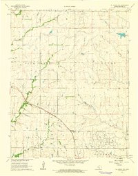
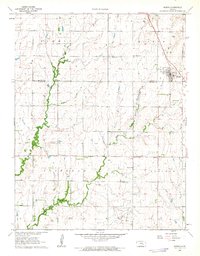
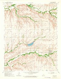
(30)- 1960 Map of Rose Hill, 1961 Print
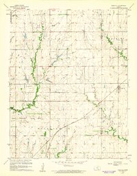 1960 Rose Hill1961 Print · USGSThe Kansas prairie south of Wichita comes alive in this mid-century survey as the region's agricultural and aviation sectors expanded. Researchers can trace the heritage of Rose Hill and its surrounding townships through local landmarks like Branson Cem, Hamilton Airport, and the Atchison Topeka and Santa Fe railroad line.2 unique versions available
 - 1960 Map of Greenwich, 1961 Print
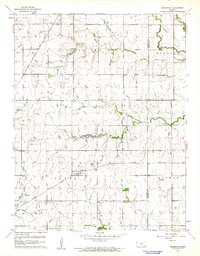 1960 Greenwich1961 Print · USGSIn the early sixties, the prairie surrounding Greenwich was a landscape of rail junctions, oil production, and deep-rooted farming communities. Genealogists can trace family connections at Greenwich Cem, Palmyra Ch, and along the historic Old Indian Boundary.3 unique versions available
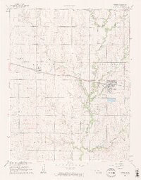
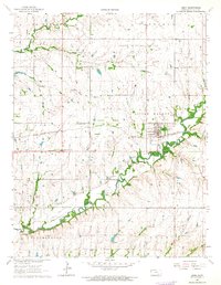
 - 1961 Map of Andover
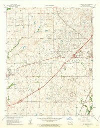
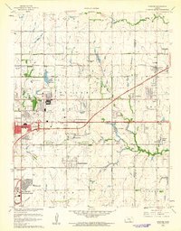 1961 Andover1961 Print · USGSEast of Wichita in the early 1960s, the landscape is a mix of rapid suburban growth and significant aviation infrastructure. Researchers can trace mid-century developments like Beech Landing Field, Mc Connell Air Force Base, and local landmarks like Seltzer Church.4 unique versions available
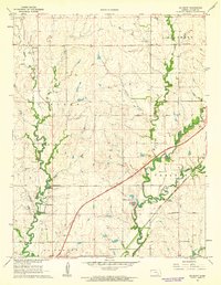
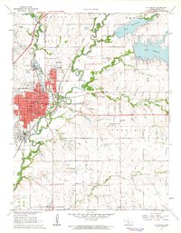
 - 1961 Map of Augusta, 1962 Print
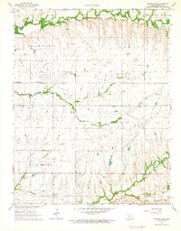
 1961 Augusta1962 Print · USGSAugusta is shown at an industrial peak in the early sixties, where the energy and rail sectors met at the river forks. Researchers can trace the sprawling Oil Refinery complex, locate rural schools like Silverton Sch, or find vanished landmarks like the Drive-in Theatre.3 unique versions available
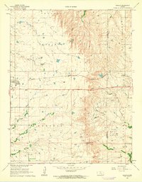
 - 1961 Map of Pontiac, 1962 Print
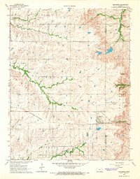
 1961 Pontiac1962 Print · USGSThe Butler County prairie in the early sixties is shown as a landscape of ranching and emerging petroleum interests. Genealogists can locate family sites near Pontiac, the Economy Cem, and the historical Old Indian Boundary.
 - 1961 Map of De Graff, 1962 Print
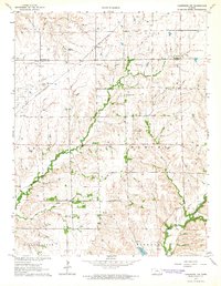
 1961 De Graff1962 Print · USGSButler County, Kansas, was a landscape of transit and tradition in the early sixties, where modern turnpikes met steam-era rail lines. Genealogists and local historians can trace the foundations of Chelsea and De Graff, or locate sites like Ridgeway Cem and Cole Creek Sch.2 unique versions available
 - 1961 Map of El Dorado NW, 1962 Print
 1961 El Dorado NW1962 Print · USGSButler County cattle and oil country come into focus during the early sixties, showing the rural grid north of the county seat. Genealogists can locate Baker Cem and the settlement of Hopkins along the Missouri Pacific line.
 - 1961 Map of Potwin, 1962 Print
 1961 Potwin1962 Print · USGSPotwin and the surrounding Butler County prairies are captured here in the early sixties, showing a landscape defined by the oil industry and the Missouri Pacific rail line. Genealogists can locate several family burial grounds like Holderman Cem and rural landmarks such as Goldengate Sch.2 unique versions available
 - 1961 Map of Rosalia NE, 1962 Print
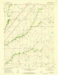
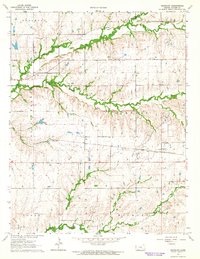
 1961 Rosalia NE1962 Print · USGSThe Flint Hills landscape at the start of the sixties reveals a transition between the Butler and Greenwood county line. Trace the Old Indian Boundary and early infrastructure like the Pumping Station along the headwaters of the Fall River.
 - 1961 Map of El Dorado, 1962 Print
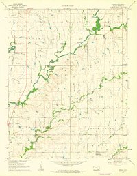
 1961 El Dorado1962 Print · USGSButler County's oil and transit network is on full display in the early sixties, centered on the industrial and educational hub of El Dorado. Trace the regional history through the Oil Refinery, the Old Indian Boundary, and local landmarks like Skelly Sch.2 unique versions available
 - 1961 Map of Rosalia, 1962 Print
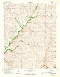
 1961 Rosalia1962 Print · USGSThe Butler and Greenwood County line in the early sixties reveals a landscape of prairie rail towns and active petroleum drilling. Trace family history at Blankinship Cem or locate old operations in the Sallyards Oil Field and Jackson Oil Field.2 unique versions available
 - 1961 Map of Rosalia NW, 1962 Print
 1961 Rosalia NW1962 Print · USGSButler County in the early sixties is captured here as the modern turnpike began to reshape the Flint Hills landscape. Genealogists and historians can trace family land in Sycamore and Chelsea, or locate the railroad stop at Aikman and the winding course of the Walnut River.2 unique versions available
 - 1961 Map of Gordon, 1962 Print
 1961 Gordon1962 Print · USGSButler County farmland in the early 1960s is defined by the winding Little Walnut River and the rural railroad village of Gordon. Genealogists and historians can trace the foundations of these communities through landmarks like Cumberland Ch, Douglass Cemetery, and the hamlet of Smileyberg.3 unique versions available
 - 1961 Map of El Dorado SW, 1963 Print
 1961 El Dorado SW1963 Print · USGSButler County witnessed a mid-century industrial boom centered around petroleum and the new turnpike. Trace the layout of oil-company towns like Midian and Oil Hill, locate the Oil Hill Sch, and follow the path of the Old Indian Boundary.2 unique versions available
 - 1962 Map of Florence SE, 1963 Print
 1962 Florence SE1963 Print · USGSThe Butler and Chase County borderlands come into focus in the early sixties as a landscape of prairie drainage and agricultural sectioning. Genealogists and historians can trace the Railroad Grade and locate features like an isolated Oil Well and the Walnut River.
 - 1962 Map of Whitewater, 1963 Print
 1962 Whitewater1963 Print · USGSButler and Harvey Counties thrive as a rail and agricultural crossroads in the early sixties, centered on the junction at Whitewater. Researchers can trace old property lines, local cemeteries like Swiss Cem, and the path of the Missouri Pacific railroad.2 unique versions available
 - 1962 Map of Burns, 1963 Print
 1962 Burns1963 Print · USGSThe rural prairie of Marion and Butler Counties is captured here in the early sixties, centered on the community of Burns. Researchers can trace old family roots at Clifford Cem or locate the historic First Mennonite Ch and Ebenezer Ch among the local oil fields.
 - 1962 Map of Peabody SE, 1963 Print
 1962 Peabody SE1963 Print · USGSThe rural borderlands of Marion and Butler Counties are captured in the early 1960s, showing a landscape shaped by the Whitewater River and oil extraction. Genealogists can locate family landmarks like Countryside Sch, Fairplay Ch, and several pioneer cemeteries.
 - 1963 Map of Leon, 1964 Print
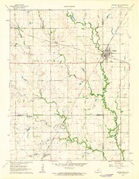
 1963 Leon1964 Print · USGSButler County's prairie landscape is captured here in the early sixties, defined by a network of petroleum fields and the St Louis-San Francisco rail line. Genealogists and historians can trace family roots through several local burial sites, such as Butts-Wakefield Cem and Bogle Cem, or locate the rural crossroads at Pickrell Corner.3 unique versions available
 - 1964 Map of Augusta SE
 1964 Augusta SE1964 Print · USGSButler County oil production is at its peak in the mid-1960s, showing a landscape densely dotted with active petroleum fields. Researchers can trace the rural church and cemetery at Bloomington Ch and Lone Star Cem alongside the Snowden Mc Sweeney Oil Field.2 unique versions available
 - 1964 Map of Beaumont, 1965 Print
 1964 Beaumont1965 Print · USGSThe railroad town of Beaumont and the surrounding Kansas prairie are captured here in the mid-1960s, showing a landscape defined by rail and river. Genealogists can trace family sites at Little Walnut Ch or locate the old Landing Field and Butts Cem.
 - 1964 Map of Latham, 1965 Print
 1964 Latham1965 Print · USGSLatham and the surrounding Butler County townships are captured here in the mid-1960s as a quiet rail-and-ranching landscape. Researchers can locate family burial sites at Latham Cem and Bryant Cem, or trace the tracks of the St. Louis San Francisco railroad.2 unique versions available
 - 1964 Map of Cambridge NW, 1965 Print
 1964 Cambridge NW1965 Print · USGSCowley County in the mid-1960s was a landscape where energy production met traditional ranching along the Old Indian Treaty Boundary. Genealogists and historians can locate the Timber Creek Cem, trace the St Louis and San Francisco rail line, and find the Mt Vernon Cem.2 unique versions available
 - 1964 Map of Keighley, 1965 Print
 1964 Keighley1965 Print · USGSButler County was a landscape of rail and river in the mid-1960s, centered on the transit hub of Keighley. Researchers can trace the path of the St Louis-San Francisco railroad or locate local landmarks like Harmony Cem and Quito Cem.2 unique versions available
 - 1964 Map of Cambridge NE, 1965 Print
 1964 Cambridge NE1965 Print · USGSThe Flint Hills of Cowley County were a hive of mid-century petroleum activity and ranching during the 1960s. Researchers can trace historical markers like the Old Indian Treaty Boundary, the Glen Grouse Cem, and the rail path of the Atchison Topeka and Santa Fe.
Showing maps 1-25 of 30
Top cities of Butler County
- El Dorado historical maps
- Andover historical maps
- Augusta historical maps
- Rose Hill historical maps
- Prospect historical maps
- Douglass historical maps
See more
Frequently asked questions
- What are the different types of historical maps available for Butler County?
- What is the oldest map of Butler County?
- Where can I purchase historical maps of Butler County for my home or office?
- Where can I download high-res historical maps of Butler County?
- Are there historical topographic maps available for Butler County?
- Is there historical aerial imagery available for Butler County?
- Where are historical maps of Butler County sourced from?