
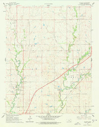
1961 Map of De Graff
USGS Topo · Published 1962About this map
The Walnut River valley in Butler County reveals a landscape defined by the convergence of early rail corridors and modern mid-century infrastructure. The southern portion of the map is anchored by the community of Chelsea, where local social life centered around the Chelsea Ch and Chelsea Sch. The path of the Atchison Topeka and Santa Fe railroad cuts across the prairie, following the drainage of Durechen Creek, while the Kansas Toll Road Turnpike introduces a high-speed transit line across the agricultural terrain.
Find a feature on this map
24 named features on this map. Tap any name to fly to it.
Don’t see what you’re looking for? This feature index may not catch every label — zoom into the map to look around manually.
Map Details
Editions of this 1961 De Graff Map
2 editions found
Other maps of this area

1888 · Eldorado
USGS Topo · 1:125,000

1898 · Cottonwood Falls
USGS Topo · 1:125,000

1955 · Wichita
USGS Topo · 1:250,000

1955 · Hutchinson
USGS Topo · 1:250,000

1958 · Wichita
USGS Topo · 1:250,000

1959 · Hutchinson
USGS Topo · 1:250,000

1961 · Pontiac
USGS Topo · 1:24,000

1961 · El Dorado NW
USGS Topo · 1:24,000

1961 · El Dorado
USGS Topo · 1:24,000
1961 · Rosalia NW
USGS Topo · 1:24,000