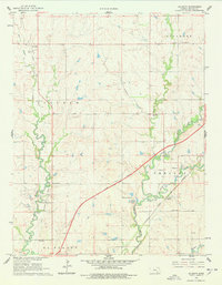
1961 Map of De Graff
USGS Topo · Published 1978About this map
The West Branch Walnut River and its various tributaries carve a winding path through Butler County, defining the early 1960s landscape of the Lincoln and Chelsea townships. Small rural centers and community infrastructure are concentrated near these watercourses, including the settlement of De Graff along the Atchison Topeka and Santa Fe Railroad. Local history is anchored by several country schools like Cole Creek Sch and West Branch Sch, along with family-linked landmarks such as Ridgeway Cem. The map illustrates a transition in regional transportation, showing the established rail corridor and the diagonal path of the Kansas Toll Road Turnpike cutting across the prairies. Numerous Oil Wells and a Quarry near the Walnut River indicate the importance of resource extraction to the local economy during this era.
Find a feature on this map
23 named features on this map. Tap any name to fly to it.
Don’t see what you’re looking for? This feature index may not catch every label — zoom into the map to look around manually.
Map Details
Editions of this 1961 De Graff Map
2 editions found
Other maps of this area

1888 · Eldorado
USGS Topo · 1:125,000

1898 · Cottonwood Falls
USGS Topo · 1:125,000

1955 · Wichita
USGS Topo · 1:250,000

1955 · Hutchinson
USGS Topo · 1:250,000

1958 · Wichita
USGS Topo · 1:250,000

1959 · Hutchinson
USGS Topo · 1:250,000

1961 · Pontiac
USGS Topo · 1:24,000

1961 · De Graff
USGS Topo · 1:24,000

1961 · El Dorado NW
USGS Topo · 1:24,000

1961 · El Dorado
USGS Topo · 1:24,000