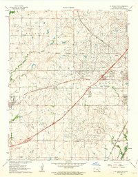
1961 Map of El Dorado SW
USGS Topo · Published 1963About this map
Industrial expansion and transit infrastructure define the landscape southwest of El Dorado in the early 1960s. The heavy footprint of the petroleum industry is evident across the terrain, marked by the extensive Oil Field with its Flowing Wells and numerous Tank Farms. Specialized company settlements like Midian and Oil Hill stand as focal points for the workforce, complete with local institutions such as the Oil Hill Sch.
Find a feature on this map
32 named features on this map. Tap any name to fly to it.
Don’t see what you’re looking for? This feature index may not catch every label — zoom into the map to look around manually.
Map Details
Editions of this 1961 El Dorado SW Map
2 editions found
Other maps of this area

1888 · Eldorado
USGS Topo · 1:125,000

1889 · Wichita
USGS Topo · 1:125,000

1894 · Wichita
USGS Topo · 1:125,000

1955 · Santa Fe Lake
USGS Topo · 1:24,000

1955 · Benton
USGS Topo · 1:24,000

1955 · Wichita
USGS Topo · 1:250,000

1958 · Wichita
USGS Topo · 1:250,000

1961 · Augusta
USGS Topo · 1:24,000

1961 · De Graff
USGS Topo · 1:24,000

1961 · El Dorado NW
USGS Topo · 1:24,000