
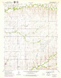
1964 Map of Augusta SE
USGS Topo · Published 1964About this map
Fox-Bush Oil Field and several neighboring petroleum sites dominate this Butler County landscape, reflecting the mid-century energy production of south-central Kansas. This 1964 survey captures a rural environment where industrial extractors sit alongside traditional agricultural features, including the small settlement of Bloomington and its nearby Bloomington Ch. The terrain is defined by a network of seasonal watercourses like Hickory Creek and Muddy Creek, which carve through the townships of Bloomington, Logan, and Rock Creek. In the southeastern corner, the Steinhoff Oil Field and the community of Clay Center mark the limits of the survey area. For genealogists and local historians, the map preserves specific points of interest such as the Lone Star Cem and numerous Gravel Pits, providing a precise record of land use and small-town infrastructure before subsequent decades of consolidation.
Find a feature on this map
19 named features on this map. Tap any name to fly to it.
Don’t see what you’re looking for? This feature index may not catch every label — zoom into the map to look around manually.
Map Details
Editions of this 1964 Augusta SE Map
2 editions found
Other maps of this area

1888 · Eldorado
USGS Topo · 1:125,000

1889 · Burden
USGS Topo · 1:125,000

1955 · Wichita
USGS Topo · 1:250,000

1958 · Wichita
USGS Topo · 1:250,000

1961 · Augusta
USGS Topo · 1:24,000

1961 · Gordon
USGS Topo · 1:24,000

1963 · Leon
USGS Topo · 1:24,000

1964 · Latham
USGS Topo · 1:24,000

1964 · Cambridge NW
USGS Topo · 1:24,000
1964 · Keighley
USGS Topo · 1:24,000