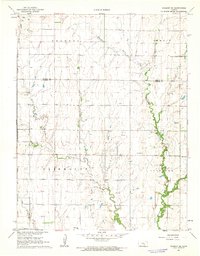
1962 Map of Peabody SE
USGS Topo · Published 1963About this map
The Whitewater River and its tributaries, including Henry Creek and Dry Creek, define the drainage patterns of this rural landscape on the border of Marion and Butler Counties. In the early 1960s, the area maintained a predominantly agricultural character, punctuated by energy development in the Elbing Oil Field and localized extraction at various Oil Wells and a Gravel Pit. The transportation network is anchored by the Chicago Rock Island and Pacific railroad, which runs north-south through the western sections. Community life is represented by widely dispersed landmarks such as Countryside Sch and rural congregations at Fairplay Ch and Whitewater Center Ch. Genealogists will find several burial sites preserved on these sections, including Fairmount Cem, Zion Cem, and Pleasant View Cem.
Find a feature on this map
20 named features on this map. Tap any name to fly to it.
Don’t see what you’re looking for? This feature index may not catch every label — zoom into the map to look around manually.
Map Details
Editions of this 1962 Peabody SE Map
This is the sole edition of this map. No revisions or reprints were ever made.
Other maps of this area

1888 · Eldorado
USGS Topo · 1:125,000

1889 · Newton
USGS Topo · 1:125,000

1889 · Wichita
USGS Topo · 1:125,000

1894 · Wichita
USGS Topo · 1:125,000

1894 · Newton
USGS Topo · 1:125,000

1898 · Cottonwood Falls
USGS Topo · 1:125,000

1955 · Wichita
USGS Topo · 1:250,000

1955 · Hutchinson
USGS Topo · 1:250,000

1957 · Peabody NW
USGS Topo · 1:24,000

1957 · Florence
USGS Topo · 1:24,000