
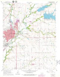
1961 Map of El Dorado
USGS Topo · Published 1962About this map
The Walnut River and its numerous tributaries, including Satchel Creek and Bemis Creek, anchor this detailed look at a mid-century Kansas oil and transportation hub. The massive Oil Refinery on the western edge of El Dorado stands as a central industrial landmark, reflecting the region's petroleum history. To the north and east, large reservoirs like Lake El Dorado and Lake Bluestem dominate the landscape, while the southern terrain is marked by the Old Indian Boundary, providing a clear reference to the area's historical land divisions.
Find a feature on this map
45 named features on this map. Tap any name to fly to it.
Don’t see what you’re looking for? This feature index may not catch every label — zoom into the map to look around manually.
Map Details
Editions of this 1961 El Dorado Map
2 editions found
Other maps of this area

1888 · Eldorado
USGS Topo · 1:125,000

1955 · Wichita
USGS Topo · 1:250,000

1958 · Wichita
USGS Topo · 1:250,000

1961 · Augusta
USGS Topo · 1:24,000

1961 · Pontiac
USGS Topo · 1:24,000

1961 · De Graff
USGS Topo · 1:24,000

1961 · El Dorado NW
USGS Topo · 1:24,000
1961 · Rosalia NW
USGS Topo · 1:24,000
1961 · El Dorado SW
USGS Topo · 1:24,000

1963 · Leon
USGS Topo · 1:24,000