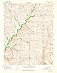
1964 Map of Cambridge NE
USGS Topo · Published 1965About this map
The Old Indian Treaty Boundary cuts across this mid-1960s landscape, marking a historical division in a region shaped by both cattle ranching and petroleum extraction. The drainage network of Grouse Creek and its tributaries, including Wagoner Creek and Ferguson Creek, dictates the movement of cattle through this section of the Flint Hills. High-country landmarks such as Ferguson Ranch sit alongside evidence of the era's energy economy, with the Grand Summit Oil Field and Manessah Oil Field scattered across the township lines. Transportation through these uplands was dominated by the Atchison Topeka and Santa Fe railroad, which snakes through the eastern terrain. Local history is anchored by the Glen Grouse Cem, providing a fixed point of reference for genealogists within a landscape of shifting ranch boundaries and active oil leases.
Find a feature on this map
21 named features on this map. Tap any name to fly to it.
Don’t see what you’re looking for? This feature index may not catch every label — zoom into the map to look around manually.
Map Details
Editions of this 1964 Cambridge NE Map
This is the sole edition of this map. No revisions or reprints were ever made.
Other maps of this area

1885 · Eureka
USGS Topo · 1:125,000

1885 · Sedan
USGS Topo · 1:125,000

1888 · Eureka
USGS Topo · 1:125,000

1888 · Eldorado
USGS Topo · 1:125,000

1889 · Burden
USGS Topo · 1:125,000

1889 · Sedan
USGS Topo · 1:125,000

1894 · Eureka
USGS Topo · 1:125,000

1955 · Wichita
USGS Topo · 1:250,000

1958 · Wichita
USGS Topo · 1:250,000

1962 · Grand Summit
USGS Topo · 1:24,000