1900s (20th Century) Maps of Elgin, Kansas
Explore 10 historic maps of Elgin from the 1900s (20th Century). These maps offer a rare glimpse into what life looked like during the 1900s — showing old roads, neighborhoods, homes, and landmarks that have changed or disappeared over time.
Whether you're researching your family's past, planning a metal detecting trip, or studying how Elgin's landscape evolved across the 1900s, these high-resolution maps are a powerful tool for exploring the history of this region.
- Focus on a specific era: All maps on this page are from the 1900s, giving you a focused view of this time period.
- See what’s changed: Compare century-old streets, trails, and buildings to today's modern landscape using overlays and satellite layers.
- Research with precision: Use these maps for genealogy, historical research, land use analysis, or educational projects.
- View, download, or print: Maps are fully viewable online in high resolution, and can be downloaded or printed for your own records.
Start exploring Elgin's history through authentic maps from the 1900s. This is your window into the past.
Elgin, KS maps
(10)- 1909 Map of Pawhuska, 1957 Print
 1909 Pawhuska1957 Print · USGSOsage County comes alive in this turn-of-the-century survey of the terrain around Pawhuska and its neighboring rail towns. Trace the paths of three major railroads as they pass through Barnsdall, find landmarks like Daltons Caves, or locate the White Swan Ford.
 - 1910 Map of Pawhuska
 1910 Pawhuska1910 Print · USGSOsage County's landscape at the dawn of Oklahoma statehood reveals a transition from tribal lands to a rail-connected economy. Genealogists and historians can trace early settlements like Wynona and Bigheart, or find local landmarks like Daltons Caves and White Swan Ford.2 unique versions available
 - 1955 Map of Wichita, 1959 Print
 1955 Wichita1959 Print · USGSSouth-central Kansas comes alive in the mid-1950s as Wichita grows into its role as a regional industrial and military powerhouse. Trace the rail-and-river network connecting El Dorado and Arkansas City through the Atchison Topeka and Santa Fe lines.3 unique versions available
 - 1955 Map of Enid, 1966 Print
 1955 Enid1966 Print · USGSNorth-central Oklahoma's transition from open plains to the blackjack hills of the Osage Indian Reservation is captured in the mid-1950s. Researchers can trace the development of the Naval Reserve Oil Field, the grounds of Vance AFB, and the early footprints of Tulsa and Stillwater.4 unique versions available
 - 1958 Map of Enid
 1958 Enid1958 Print · USGSNorthern Oklahoma is mapped here in the late fifties, showcasing a dense network of petroleum production and historic tribal lands. Researchers can trace the legacy of the Osage Indian Reservation, early energy hubs like the Cushing Oil Field, and the Chilocco Indian Agricultural School.2 unique versions available
 - 1958 Map of Wichita
 1958 Wichita1958 Print · USGSSouth Central Kansas in the late fifties was a landscape of aviation industry, oil exploration, and expanding turnpikes. Researchers can trace mid-century growth through McConnell Air Force Base, major facilities for Cessna Aircraft Company, and the active El Dorado Oil Field.
 - 1962 Map of Elgin, 1963 Print
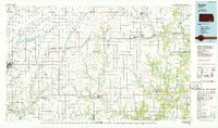
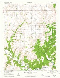 1962 Elgin1963 Print · USGSElgin and the Chautauqua County borderlands are documented here in the early 1960s, just as the Hulah Res shaped the local hydrology. Genealogists can trace family roots at Moore Prairie Cem or follow the Old Indian Treaty Boundary across the Caney River.3 unique versions available
 - 1973 Map of Pearsonia NE, 1975 Print
 1973 Pearsonia NE1975 Print · USGSOsage County and the Oklahoma-Kansas border are captured in the early 1970s as the regional petroleum economy shaped the valley. Trace the industrial footprint of the Oil Field and Oil Wells surrounding Hulah Lake and the Caney River.
 - 1985 Map of Sedan
 1985 Sedan1985 Print · USGSSoutheast Kansas in the mid-1980s is defined by rail towns and prairie waterways along the Chautauqua and Cowley county lines. Researchers can trace the Atchison Topeka and Santa Fe line through Grenola or locate the Indian Treaty Boundary and Kaw State Wildlife Area.2 unique versions available
 - 1985 Map of Pawhuska, 1986 Print
 1985 Pawhuska1986 Print · USGSThe Osage Indian Reservation and its tribal capital at Pawhuska are seen here in the mid-1980s as the region's ranching and oil legacies matured. Genealogists and historians can trace family-named sites and vanished industrial tracks near Bigheart, Wynona, and Gray Horse.2 unique versions available
End of results
Showing maps 1-10 of 10
Top cities near Elgin
Frequently asked questions
- What are the different types of historical maps available for Elgin?
- What is the oldest map of Elgin?
- Where can I purchase historical maps of Elgin for my home or office?
- Where can I download high-res historical maps of Elgin?
- Are there historical topographic maps available for Elgin?
- Is there historical aerial imagery available for Elgin?
- Where are historical maps of Elgin sourced from?