1960s Maps of Clark County, Kansas
Explore 3 historic maps of Clark County from the 1960s. These maps offer a rare glimpse into what life looked like during the 1960s — showing old roads, neighborhoods, homes, and landmarks that have changed or disappeared over time.
Whether you're researching your family's past, planning a metal detecting trip, or studying how Clark County's landscape evolved across the 1960s, these high-resolution maps are a powerful tool for exploring the history of this region.
- Focus on a specific era: All maps on this page are from the 1960s, giving you a focused view of this time period.
- See what’s changed: Compare century-old streets, trails, and buildings to today's modern landscape using overlays and satellite layers.
- Research with precision: Use these maps for genealogy, historical research, land use analysis, or educational projects.
- View, download, or print: Maps are fully viewable online in high resolution, and can be downloaded or printed for your own records.
Start exploring Clark County's history through authentic maps from the 1960s. This is your window into the past.
Clark County, KS maps
(3)- 1967 Map of Bloom, 1968 Print
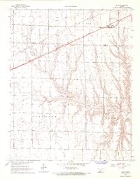 1967 Bloom1968 Print · USGSBloom and the surrounding Kansas plains were firmly defined by the rail and ranching economy in the late sixties. Researchers can trace the CHICAGO Rock Island and Pacific railroad and the historic Old Indian Treaty Boundary near Bloom Cem.
 - 1967 Map of Fowler SE, 1968 Print
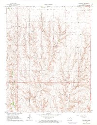 1967 Fowler SE1968 Print · USGSThe high plains of Clark County meet the winding drainages of the eastern Meade County line in the mid-1960s. Genealogists and local historians can trace the geography of early townships like Appleton and Vesta alongside the course of Old Indian Treaty Creek.
 - 1967 Map of Minneola, 1968 Print
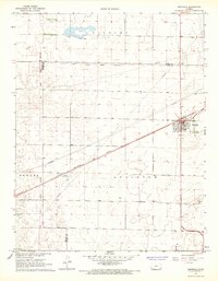 1967 Minneola1968 Print · USGSMinneola and the surrounding plains were a hub of rail and regional boundary lines in the late 1960s. Genealogists and researchers can trace the Old Indian Treaty Boundary across the county line and locate sites like the Kennedy Glider Port and Minneola Cem.
End of results
Showing maps 1-3 of 3
Top cities of Clark County
- Ashland historical maps
- Minneola historical maps
- Englewood historical maps
- Sitka historical maps
- Lexington historical maps
Frequently asked questions
- What are the different types of historical maps available for Clark County?
- What is the oldest map of Clark County?
- Where can I purchase historical maps of Clark County for my home or office?
- Where can I download high-res historical maps of Clark County?
- Are there historical topographic maps available for Clark County?
- Is there historical aerial imagery available for Clark County?
- Where are historical maps of Clark County sourced from?