1970s Maps of Dickinson County, Kansas
Explore 2 historic maps of Dickinson County from the 1970s. These maps offer a rare glimpse into what life looked like during the 1970s — showing old roads, neighborhoods, homes, and landmarks that have changed or disappeared over time.
Whether you're researching your family's past, planning a metal detecting trip, or studying how Dickinson County's landscape evolved across the 1970s, these high-resolution maps are a powerful tool for exploring the history of this region.
- Focus on a specific era: All maps on this page are from the 1970s, giving you a focused view of this time period.
- See what’s changed: Compare century-old streets, trails, and buildings to today's modern landscape using overlays and satellite layers.
- Research with precision: Use these maps for genealogy, historical research, land use analysis, or educational projects.
- View, download, or print: Maps are fully viewable online in high resolution, and can be downloaded or printed for your own records.
Start exploring Dickinson County's history through authentic maps from the 1970s. This is your window into the past.
Dickinson County, KS maps
(2)- 1972 Map of Lost Springs, 1974 Print
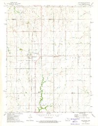 1972 Lost Springs1974 Print · USGSLost Springs and the surrounding Marion County countryside are captured here in the early seventies at a peak of rail and resource activity. Researchers can trace the junction of the Chicago Topeka and Santa Fe and the Chicago Rock Island and Pacific railroads near Old Mission Cem and active Oil Wells.
 - 1972 Map of Herington, 1974 Print
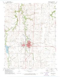 1972 Herington1974 Print · USGSHerington in the early seventies remains a vital rail crossroads for Morris and Dickinson counties. Researchers can trace the legacy of local families through landmarks like Sunset Hill Cem, St Johns Cem, and the LOST SPRINGS OIL FIELD.
End of results
Showing maps 1-2 of 2
Top cities of Dickinson County
- Abilene historical maps
- Herington historical maps
- Chapman historical maps
- Chapman historical maps
- Enterprise historical maps
- Buckeye historical maps
See more
Frequently asked questions
- What are the different types of historical maps available for Dickinson County?
- What is the oldest map of Dickinson County?
- Where can I purchase historical maps of Dickinson County for my home or office?
- Where can I download high-res historical maps of Dickinson County?
- Are there historical topographic maps available for Dickinson County?
- Is there historical aerial imagery available for Dickinson County?
- Where are historical maps of Dickinson County sourced from?