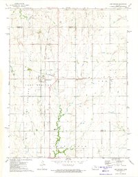
1972 Map of Lost Springs
USGS Topo · Published 1974About this map
The town of Lost Springs serves as the central hub of this northern Marion County landscape during the early 1970s. The area is defined by its significant transportation corridors, where the Chicago Rock Island and Pacific railroad intersects with the Chicago Topeka and Santa Fe line, illustrating the region's enduring importance as a rail junction. The map reveals a settled agricultural and industrial pattern, evidenced by numerous Oil Wells scattered across the township and the presence of the Centre High Sch situated near Clear Creek.
Find a feature on this map
23 named features on this map. Tap any name to fly to it.
Don’t see what you’re looking for? This feature index may not catch every label — zoom into the map to look around manually.
Map Details
Editions of this 1972 Lost Springs Map
This is the sole edition of this map. No revisions or reprints were ever made.
Other maps of this area

1889 · Newton
USGS Topo · 1:125,000

1889 · Abilene
USGS Topo · 1:125,000

1889 · Parkerville
USGS Topo · 1:125,000

1894 · Newton
USGS Topo · 1:125,000

1894 · Abilene
USGS Topo · 1:125,000

1894 · Parkerville
USGS Topo · 1:125,000

1898 · Cottonwood Falls
USGS Topo · 1:125,000

1955 · Hutchinson
USGS Topo · 1:250,000

1959 · Hutchinson
USGS Topo · 1:250,000

1964 · Ramona
USGS Topo · 1:24,000