1970s Maps of Ford County, Kansas
Explore 11 historic maps of Ford County from the 1970s. These maps offer a rare glimpse into what life looked like during the 1970s — showing old roads, neighborhoods, homes, and landmarks that have changed or disappeared over time.
Whether you're researching your family's past, planning a metal detecting trip, or studying how Ford County's landscape evolved across the 1970s, these high-resolution maps are a powerful tool for exploring the history of this region.
- Focus on a specific era: All maps on this page are from the 1970s, giving you a focused view of this time period.
- See what’s changed: Compare century-old streets, trails, and buildings to today's modern landscape using overlays and satellite layers.
- Research with precision: Use these maps for genealogy, historical research, land use analysis, or educational projects.
- View, download, or print: Maps are fully viewable online in high resolution, and can be downloaded or printed for your own records.
Start exploring Ford County's history through authentic maps from the 1970s. This is your window into the past.
Ford County, KS maps
(11)- 1972 Map of Bellefont, 1974 Print
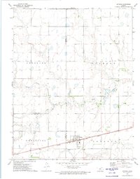
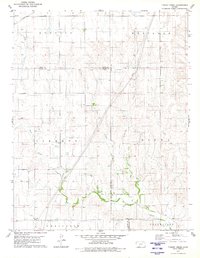
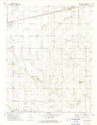 1972 Bellefont1974 Print · USGSIn the early 1970s, this Ford County landscape was defined by the intersection of the Atchison Topeka and Santa Fe rail line and a historic Old Indian Treaty Boundary. Genealogists and local historians can trace the foundations of Windhorst, the Holy Cross Cem, and the small siding at Bellefont.
 - 1972 Map of Offerle SE, 1974 Print
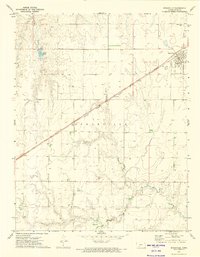
 1972 Offerle SE1974 Print · USGSThe Ford and Edwards County line in the early 1970s reveals a landscape shaped by historical divisions and river geography. Researchers can locate the Old Indian Treaty Boundary and trace landmarks like the Zion Ch along Coon Creek.2 unique versions available
 - 1972 Map of Wright, 1974 Print
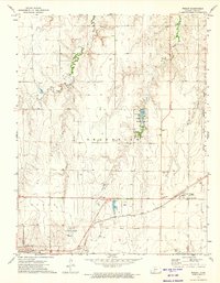 1972 Wright1974 Print · USGSThe High Plains of Ford County come into focus in the early 1970s, showcasing the intersection of the Atchison Topeka and Santa Fe rail line and the historic Old Indian Treaty Boundary. Trace the local landscape through Wright, the Pleasant Vale Cem, and Ford County State Park.
 - 1972 Map of Spearville, 1974 Print
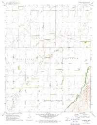
 1972 Spearville1974 Print · USGSSpearville and the surrounding Ford County plains are captured in the early seventies during an era of established rail and ranching. Genealogists and historians can trace cemetery locations like St Johns Cem and the path of the Old Indian Treaty Boundary.2 unique versions available
 - 1972 Map of Offerle, 1974 Print
 1972 Offerle1974 Print · USGSOfferle emerges as a rail-side hub in the early 1970s, where the high plains meet the intricate drainage of Coon Creek. Researchers can locate significant burial sites like St Joseph Cem and trace the path of the Atchison Topeka and Santa Fe railroad.
 - 1972 Map of Spearville NW, 1974 Print
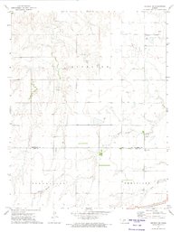
 1972 Spearville NW1974 Print · USGSThe high plains of western Kansas are captured here in the early 1970s, showcasing the transition from military frontier to modern energy and aviation. Researchers can trace the Fort Dodge Military Reservation Boundary and locate local landmarks like the Jetmore Municipal Airport and Saw Log Creek.
 - 1972 Map of Spearville NE, 1974 Print
 1972 Spearville NE1974 Print · USGSThe High Plains of the Kansas-Oklahoma border region are captured here in the early seventies, spanning the line between Hodgeman and Ford Counties. Researchers can locate an active Oil Field, the Jetmore Municipal Airport, and the winding course of Saw Log Creek.2 unique versions available
 - 1972 Map of Offerle NW, 1974 Print
 1972 Offerle NW1974 Print · USGSThe Kansas prairie at the boundary of Hodgeman and Ford counties shows its agricultural and industrial character in the early seventies. Genealogists can locate St Marys Ch and Old St Joseph Cem near the Atchison Topeka and Santa Fe line.
 - 1979 Map of Turkey Creek, 1980 Print
 1979 Turkey Creek1980 Print · USGSSouthwest Kansas prairie land is captured here in the late seventies, showing the intersection of several historic townships and county lines. Researchers can trace the Old Indian Treaty Boundary and locate early energy infrastructure like the Gas Well sites near West Kiowa Creek.
 - 1979 Map of Simmons Creek, 1980 Print
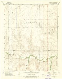
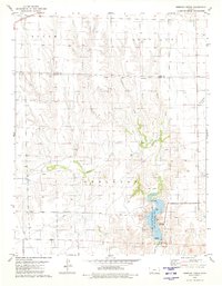 1979 Simmons Creek1980 Print · USGSFord and Clark counties were deeply shaped by early land treaties and the arrival of the railroad in the late 1970s. Researchers can trace the Old Indian Treaty Boundary and locate infrastructure like the C R I & P railroad and Clark State Fishing Lake.
 - 1979 Map of Mount Jesus NW, 1980 Print
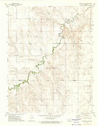
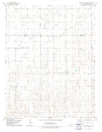 1979 Mount Jesus NW1980 Print · USGSThe high plains of Clark and Ford counties are captured here in the late 1970s, revealing a landscape etched with historical survey lines. Researchers can trace the Old Indian Treaty Boundary and explore the rural townships of Sodville and Appleton.
End of results
Showing maps 1-11 of 11
Top cities of Ford County
- Dodge City historical maps
- Spearville historical maps
- Bucklin historical maps
- Ford historical maps
- Bloom historical maps
Frequently asked questions
- What are the different types of historical maps available for Ford County?
- What is the oldest map of Ford County?
- Where can I purchase historical maps of Ford County for my home or office?
- Where can I download high-res historical maps of Ford County?
- Are there historical topographic maps available for Ford County?
- Is there historical aerial imagery available for Ford County?
- Where are historical maps of Ford County sourced from?