Old Maps of Geary County, Kansas for Hiking & Exploration
Hike through history with 113 historic maps of Geary County. Explore old trails, ghost towns, and forgotten backroads — perfect for outdoor adventurers and local explorers.
- Rediscover forgotten places: Map out old mining camps, roads, and footpaths that no longer exist on modern maps.
- Layer with modern tools: Combine with LiDAR or satellite views to plan hikes through historical terrain.
- Made for exploration: Popular among hikers, overlanders, and local history lovers.
Use these maps to find adventure and explore the hidden past of Geary County.
Geary County, KS maps
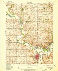
(113)- 1886 Map of Junction City, 1960 Print
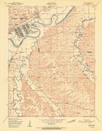
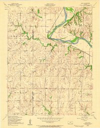
 1886 Junction City1960 Print · USGSNortheastern Kansas in the late nineteenth century centers on the strategic military and rail hubs of the Flint Hills. Genealogists can trace the early foundations of Junction City, the sprawling Fort Riley Military Reservation, and rail-stop towns like Garrison and Stockdale.
 - 1889 Map of Junction City
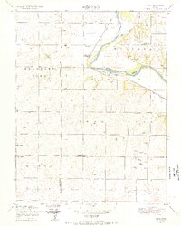
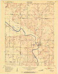
 1889 Junction City1889 Print · USGSThe confluence of the Republican and Smoky Hill rivers defines this central Kansas landscape in the late nineteenth century. Genealogists and historians can trace the early footprints of Fort Riley, the rail hubs of Junction City and Manhattan, and vanished stops like Garrison and Bala.
 - 1889 Map of Parkerville
 1889 Parkerville1889 Print · USGSMorris and Marion County townships appear here during the great western rail boom. Genealogists and historians can trace the early layouts of Parkerville, White City, and Herrington along the Chicago Kansas and Nebraska Railroad.
 - 1894 Map of Junction City
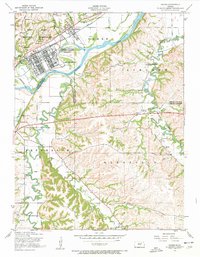
 1894 Junction City1894 Print · USGSThe Kansas frontier of the late nineteenth century comes alive as the rail-and-river network expands around Junction City. Genealogists and historians can trace early townships and rural outposts like Riley Center, Bala, and the Fort Riley Military Reservation.7 unique versions available
 - 1894 Map of Parkerville
 1894 Parkerville1894 Print · USGSEastern Kansas at the height of the steam era shows a landscape transformed by competing rail lines and growing prairie towns. Genealogists and historians can trace early settlements like White City, Parkerville, and the riverside hub of Council Grove.6 unique versions available
 - 1947 Map of Manhattan, 1954 Print
 1947 Manhattan1954 Print · USGSManhattan and the surrounding Kansas river valleys are shown here in the years immediately following World War II. Researchers can trace the extensive military works at Camp Funston, local education at College Hill Sch, and pioneer-era sites like St Patricks Cem.2 unique versions available
 - 1947 Map of Fort Riley, 1954 Print
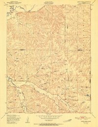
 1947 Fort Riley1954 Print · USGSPost-war Kansas comes to life where the Smoky Hill and Republican rivers meet to form the Kansas River. Genealogists and historians can trace the foundations of Fort Riley, early settlements like Milford, and dozens of rural schools including Walla Walla Sch and Acme Sch.2 unique versions available
 - 1950 Map of Junction City
 1950 Junction City1950 Print · USGSThe Kansas river forks and the vast Fort Riley complex dominate this mid-century landscape. Researchers can trace local roots through the Highland Cemetery, Grand View School, and the early layout of Camp Forsyth.2 unique versions available
 - 1950 Map of Alida
 1950 Alida1950 Print · USGSMid-century Kansas life along the Republican River is preserved here just as the post-war era reshaped the plains. Genealogists and local historians can locate early schools like Walla Walla School and burial grounds including Bethel Cemetery.2 unique versions available
 - 1951 Map of Swede Creek
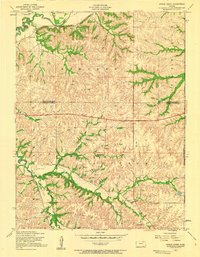
 1951 Swede Creek1951 Print · USGSThe rural borderlands of Geary and Riley counties are captured here in the early fifties, showing a landscape shaped by the McDowell Creek watershed. Researchers can trace family history through sites like Ashland Cemetery, Briggs School, and Cleveland School.2 unique versions available
 - 1951 Map of Ogden
 1951 Ogden1951 Print · USGSThe Kansas River valley near Ogden is shown here at mid-century, where the expansion of the military post meets established rural life. Researchers can trace the layout of Camp Funston, find several family burial grounds like St Marys Cemetery, and locate vanished local schools including Tully School and Reynalda School.2 unique versions available
 - 1951 Map of Wind Creek
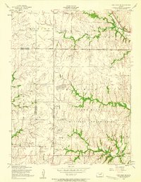
 1951 Wind Creek1951 Print · USGSRiley and Geary counties are captured here just after the war, showing the expansion of military lands into traditional Kansas farming territory. Researchers can trace rural landmarks like Liberty Cemetery and Magic School alongside the active vehicle firing range of the Fort Riley Military Reservation.2 unique versions available
 - 1951 Map of Milford
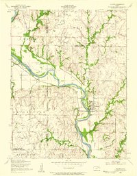
 1951 Milford1951 Print · USGSThe Republican River valley remains unchanged in this mid-century portrait of Milford before modern developments altered the local drainage. Genealogists and historians can locate rural landmarks like Acme School District 92 and the Milford Cemetery.
 - 1955 Map of Ogden
 1955 Ogden1955 Print · USGSThe military and rural landscapes of Riley and Geary counties meet here in the mid-1950s where the river bends. Researchers can trace historic burial sites like St Marys Cem and old country schoolhouses including Berry School and Humboldt School.3 unique versions available
 - 1955 Map of Fort Riley NE, 1958 Print
 1955 Fort Riley NE1958 Print · USGSRiley and Geary counties are captured here in the mid-fifties, showcasing the expansive military and rural landscape of northeastern Kansas. Researchers can locate family landmarks like Shanks Cemetery and trace vanished school districts such as Magic School or Vinton School.3 unique versions available
 - 1955 Map of Swede Creek, 1958 Print
 1955 Swede Creek1958 Print · USGSThe rural borderlands of Geary and Riley counties are captured here in the mid-fifties, showing a landscape defined by creek valleys and farm life. Genealogists and researchers can locate landmarks like Ashland Cem, Briggs School, and the junction of McDowell Creek and Swede Creek.3 unique versions available
 - 1955 Map of Milford, 1958 Print
 1955 Milford1958 Print · USGSThe Republican River valley in the mid-1950s was a landscape of small schools and prairie churches before major reservoir projects altered the terrain. Genealogists can trace family footprints at Timber Creek Cem, Zoar School, and the Indian Grave Monument.3 unique versions available
 - 1955 Map of Junction City, 1958 Print
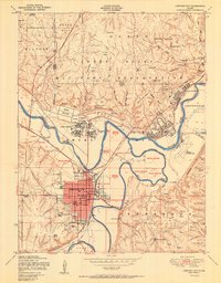
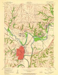 1955 Junction City1958 Print · USGSJunction City and the Fort Riley Military Reservation are captured here in the mid-fifties at the historic meeting of the Republican and Smoky Hill rivers. Researchers can locate civic landmarks like the Courthouse, local schools, and the Kansas First Territorial Capitol.2 unique versions available
 - 1955 Map of Alida, 1958 Print
 1955 Alida1958 Print · USGSThe Republican River valley of Geary and Dickinson counties is captured here in the mid-fifties, just before the landscape was reshaped. Researchers can trace the original locations of rural landmarks like Alida, the Walla Walla School, and St Johns Cem.3 unique versions available
 - 1955 Map of Manhattan, 1964 Print
 1955 Manhattan1964 Print · USGSNorth Central Kansas is captured here in the mid-fifties, just as major flood control projects began reshaping the river valleys. Genealogists can locate family sites near St. Joseph Church, Sunset Cemetery, or along the busy tracks of the Rock Island RR.4 unique versions available
 - 1955 Map of Hutchinson, 1967 Print
 1955 Hutchinson1967 Print · USGSCentral Kansas in the mid-sixties reveals a landscape of growing reservoirs and evolving transportation corridors. Trace the development of towns like Hutchinson and Abilene alongside the Union Pacific Railroad and the expanding Interstate 70.3 unique versions available
 - 1956 Map of Manhattan
 1956 Manhattan1956 Print · USGSNorth-central Kansas in the mid-fifties reveals a landscape defined by the convergence of the Republican River and Smoky Hill River. Historians can trace the rail corridors of the Union Pacific RR and Missouri Pacific RR through towns like Manhattan and Clay Center.
 - 1957 Map of Manhattan
 1957 Manhattan1957 Print · USGSNortheast Kansas in the mid-1950s reveals a landscape of expanding military installations and new water projects. Genealogists and historians can trace the rail-to-river economy through the Union Pacific RR and old settlements like Clay Center or Marysville.
 - 1959 Map of Hutchinson
 1959 Hutchinson1959 Print · USGSCentral Kansas thrives at the intersection of rail and river in the mid-1950s, as post-war aviation infrastructure reshapes the prairie. Genealogists and historians can trace the paths of the AT&SF RR through Newton and Hutchinson, or locate military sites like Smoky Hill Air Force Base.2 unique versions available
 - 1964 Map of Skiddy, 1965 Print
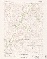 1964 Skiddy1965 Print · USGSThe rural landscapes of Morris and Geary Counties are captured in the mid-1960s, showing the settlement of Skiddy at a crossroads of rail and stream. Researchers can trace the active Chicago Rock Island and Pacific line or follow the path of an Old Railroad Grade along Clarks Creek.2 unique versions available
Showing maps 1-25 of 113
Top cities of Geary County
Frequently asked questions
- What are the different types of historical maps available for Geary County?
- What is the oldest map of Geary County?
- Where can I purchase historical maps of Geary County for my home or office?
- Where can I download high-res historical maps of Geary County?
- Are there historical topographic maps available for Geary County?
- Is there historical aerial imagery available for Geary County?
- Where are historical maps of Geary County sourced from?