1970s Maps of Geary County, Kansas
Explore 4 historic maps of Geary County from the 1970s. These maps offer a rare glimpse into what life looked like during the 1970s — showing old roads, neighborhoods, homes, and landmarks that have changed or disappeared over time.
Whether you're researching your family's past, planning a metal detecting trip, or studying how Geary County's landscape evolved across the 1970s, these high-resolution maps are a powerful tool for exploring the history of this region.
- Focus on a specific era: All maps on this page are from the 1970s, giving you a focused view of this time period.
- See what’s changed: Compare century-old streets, trails, and buildings to today's modern landscape using overlays and satellite layers.
- Research with precision: Use these maps for genealogy, historical research, land use analysis, or educational projects.
- View, download, or print: Maps are fully viewable online in high resolution, and can be downloaded or printed for your own records.
Start exploring Geary County's history through authentic maps from the 1970s. This is your window into the past.
Geary County, KS maps
(4)- 1971 Map of White City NW, 1974 Print
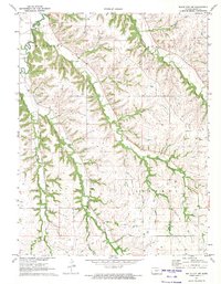 1971 White City NW1974 Print · USGSGeary County in the early seventies shows a landscape of upland prairies and deeply carved creek valleys between the townships of Liberty and Jefferson. Genealogists can locate family landmarks like Olson Cem and Rosey Cem or trace the drainage of Humboldt Creek.
 - 1971 Map of Dwight, 1974 Print
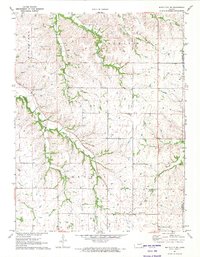
 1971 Dwight1974 Print · USGSThe town of Dwight and its surrounding prairie landscape are shown here in the early 1970s at the intersection of Morris and Geary counties. Local historians can trace the Chicago Rock Island and Pacific rail line and search for family roots at Swartz Cem or Kelso Cem.
 - 1971 Map of White City NE, 1974 Print
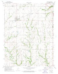
 1971 White City NE1974 Print · USGSGeary County in the early 1970s is characterized by its network of creek-side farmsteads and rural cemeteries. Genealogists can trace family footprints near Upper Humboldt Cem, Quaker Cem, and the historic Townhall site.
 - 1971 Map of White City, 1974 Print
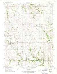 1971 White City1974 Print · USGSWhite City and Parkerville are shown at a turning point in the early 1970s as rail transit evolved alongside traditional Kansas farming. Genealogists and historians can trace local family landmarks like Ramsey-Black Cem and the OLD RAILROAD GRADE near the Neosho River.
End of results
Showing maps 1-4 of 4
Top cities of Geary County
Frequently asked questions
- What are the different types of historical maps available for Geary County?
- What is the oldest map of Geary County?
- Where can I purchase historical maps of Geary County for my home or office?
- Where can I download high-res historical maps of Geary County?
- Are there historical topographic maps available for Geary County?
- Is there historical aerial imagery available for Geary County?
- Where are historical maps of Geary County sourced from?