1960s Maps of Geary County, Kansas
Explore 4 historic maps of Geary County from the 1960s. These maps offer a rare glimpse into what life looked like during the 1960s — showing old roads, neighborhoods, homes, and landmarks that have changed or disappeared over time.
Whether you're researching your family's past, planning a metal detecting trip, or studying how Geary County's landscape evolved across the 1960s, these high-resolution maps are a powerful tool for exploring the history of this region.
- Focus on a specific era: All maps on this page are from the 1960s, giving you a focused view of this time period.
- See what’s changed: Compare century-old streets, trails, and buildings to today's modern landscape using overlays and satellite layers.
- Research with precision: Use these maps for genealogy, historical research, land use analysis, or educational projects.
- View, download, or print: Maps are fully viewable online in high resolution, and can be downloaded or printed for your own records.
Start exploring Geary County's history through authentic maps from the 1960s. This is your window into the past.
Geary County, KS maps
(4)- 1964 Map of Skiddy, 1965 Print
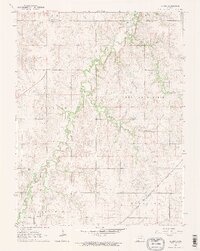 1964 Skiddy1965 Print · USGSThe rural landscapes of Morris and Geary Counties are captured in the mid-1960s, showing the settlement of Skiddy at a crossroads of rail and stream. Researchers can trace the active Chicago Rock Island and Pacific line or follow the path of an Old Railroad Grade along Clarks Creek.2 unique versions available
 - 1964 Map of Kansas Falls, 1965 Print
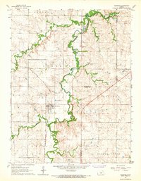
 1964 Kansas Falls1965 Print · USGSMid-century Dickinson County is defined by the winding waters of the Smoky Hill and Lyon Creek. Genealogists and local historians can trace rural landmarks including Rinehart Cem, Mt Zion Ch, and the oxbows surrounding Goat Island.2 unique versions available
 - 1964 Map of Wreford, 1965 Print
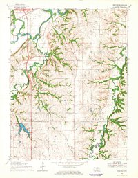 1964 Wreford1965 Print · USGSGeary County in the mid-1960s features a landscape shaped by the Smoky Hill River and established rail corridors. Genealogists and local historians can trace family roots through the Skiddy Cem, Salchow Cem, and the rural community at Wreford.
 - 1964 Map of Woodbine, 1966 Print
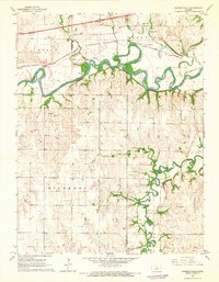
 1964 Woodbine1966 Print · USGSMid-century Woodbine sits at the heart of an active rail and ranching landscape where Dickinson, Morris, and Geary counties meet. Genealogists and historians can trace the Rock Island line, find the Carry Creek Sch, and locate family plots at Woodbine Cem.
End of results
Showing maps 1-4 of 4
Top cities of Geary County
Frequently asked questions
- What are the different types of historical maps available for Geary County?
- What is the oldest map of Geary County?
- Where can I purchase historical maps of Geary County for my home or office?
- Where can I download high-res historical maps of Geary County?
- Are there historical topographic maps available for Geary County?
- Is there historical aerial imagery available for Geary County?
- Where are historical maps of Geary County sourced from?