1960s Maps of Haskell County, Kansas
Explore 8 historic maps of Haskell County from the 1960s. These maps offer a rare glimpse into what life looked like during the 1960s — showing old roads, neighborhoods, homes, and landmarks that have changed or disappeared over time.
Whether you're researching your family's past, planning a metal detecting trip, or studying how Haskell County's landscape evolved across the 1960s, these high-resolution maps are a powerful tool for exploring the history of this region.
- Focus on a specific era: All maps on this page are from the 1960s, giving you a focused view of this time period.
- See what’s changed: Compare century-old streets, trails, and buildings to today's modern landscape using overlays and satellite layers.
- Research with precision: Use these maps for genealogy, historical research, land use analysis, or educational projects.
- View, download, or print: Maps are fully viewable online in high resolution, and can be downloaded or printed for your own records.
Start exploring Haskell County's history through authentic maps from the 1960s. This is your window into the past.
Haskell County, KS maps
(8)- 1960 Map of Hickok SE, 1961 Print
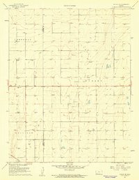 1960 Hickok SE1961 Print · USGSHaskell and Grant Counties are captured here at the start of the 1960s as energy infrastructure transformed the landscape. Researchers can trace the densification of Gas Wells across Dudley and Sullivan townships and locate the Canaan Cem.2 unique versions available
 - 1960 Map of Garden City 3 SW, 1961 Print
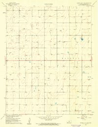 1960 Garden City 3 SW1961 Print · USGSHaskell County at the dawn of the 1960s reveals a prairie landscape transformed by the energy industry. Genealogists and historians can trace the grid of the Hugoton Gas Area through dozens of Gas Well sites and locate the Haskell Cem.3 unique versions available
 - 1960 Map of Garden City 3 SE, 1961 Print
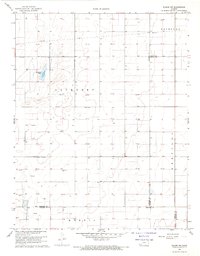
 1960 Garden City 3 SE1961 Print · USGSHaskell County's high plains are captured in the early sixties during a period of intense energy development and railroad transport. Researchers can trace the Atchison Topeka and Santa Fe rail line and locate the historic Haskell Cem or the remnants of an Abandoned Canal.3 unique versions available
 - 1968 Map of Plains NW, 1969 Print
 1968 Plains NW1969 Print · USGSThe high plains at the corner of Haskell, Meade, and Seward counties are captured here in the late sixties during a period of expanding energy infrastructure. Researchers can locate family-named landmarks like Ellsaesser Pond and trace township boundaries from Lockport to Morris.2 unique versions available
 - 1968 Map of Satanta, 1970 Print
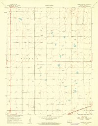
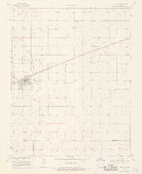 1968 Satanta1970 Print · USGSHaskell County underwent a significant industrial shift in the late sixties as the energy sector expanded across the high plains. Genealogists and historians can locate the Satanta townsite, the Dudley Cem, and the massive Victory and Gas Field network.
 - 1968 Map of Sublette, 1970 Print
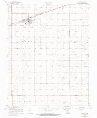 1968 Sublette1970 Print · USGSSublette and the surrounding Kansas prairie are captured here in the late sixties, showing a landscape defined by energy and rail. Genealogists and local historians can trace the town's footprint including the High Sch, the Atchison Topeka and Santa Fe railroad, and the Sublette Flying Club Landing Strip.2 unique versions available
 - 1969 Map of Copeland, 1971 Print
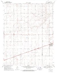 1969 Copeland1971 Print · USGSGray and Haskell counties show their agricultural foundations in the late sixties as the railroad drives local commerce. Genealogists and researchers can trace property lines through Lockport and locate features like the Cem and the siding at Tice.
 - 1969 Map of Copeland NW, 1971 Print
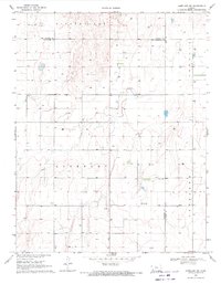 1969 Copeland NW1971 Print · USGSHaskell and Gray counties come together in the Kansas high plains during the late sixties, showing a landscape defined by industrial agriculture and mineral wells. Genealogists and historians can locate Colusa Cem, the Salem Ch, and the Radio Tower (KUPK-TV).
End of results
Showing maps 1-8 of 8
Top cities of Haskell County
Frequently asked questions
- What are the different types of historical maps available for Haskell County?
- What is the oldest map of Haskell County?
- Where can I purchase historical maps of Haskell County for my home or office?
- Where can I download high-res historical maps of Haskell County?
- Are there historical topographic maps available for Haskell County?
- Is there historical aerial imagery available for Haskell County?
- Where are historical maps of Haskell County sourced from?