1970s Maps of Hodgeman County, Kansas
Explore 21 historic maps of Hodgeman County from the 1970s. These maps offer a rare glimpse into what life looked like during the 1970s — showing old roads, neighborhoods, homes, and landmarks that have changed or disappeared over time.
Whether you're researching your family's past, planning a metal detecting trip, or studying how Hodgeman County's landscape evolved across the 1970s, these high-resolution maps are a powerful tool for exploring the history of this region.
- Focus on a specific era: All maps on this page are from the 1970s, giving you a focused view of this time period.
- See what’s changed: Compare century-old streets, trails, and buildings to today's modern landscape using overlays and satellite layers.
- Research with precision: Use these maps for genealogy, historical research, land use analysis, or educational projects.
- View, download, or print: Maps are fully viewable online in high resolution, and can be downloaded or printed for your own records.
Start exploring Hodgeman County's history through authentic maps from the 1970s. This is your window into the past.
Hodgeman County, KS maps
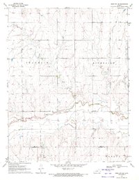
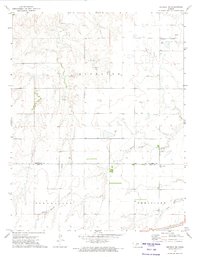
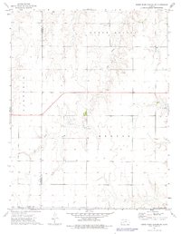
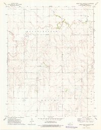
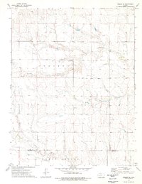
(21)- 1970 Map of Jetmore SE, 1971 Print
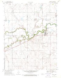
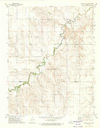
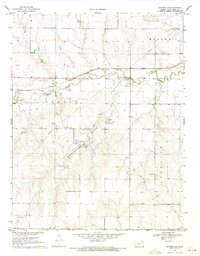 1970 Jetmore SE1971 Print · USGSWestern Kansas ranching and energy production intersect in the 1970s along the Buckner Creek valley. Researchers can trace the Atchison Topeka and Santa Fe rail line or locate specific historical sites like the Lippoldt Oil Field and Hodgeman County State Park.
 - 1970 Map of Hanston, 1971 Print
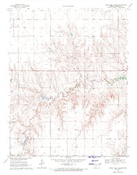
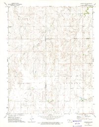
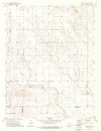
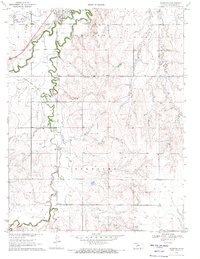 1970 Hanston1971 Print · USGSHodgeman County's agricultural and energy landscape comes into focus around 1970, centered on the community of Hanston. Researchers can trace early infrastructure and family landmarks through features like St Anthony Cem, the Orwell settlement, and several active oil fields.
 - 1970 Map of Hanston NW, 1971 Print
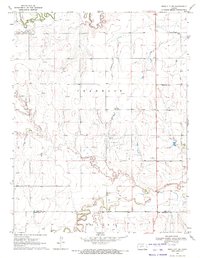
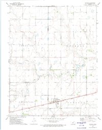
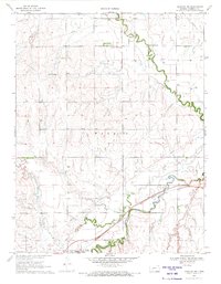 1970 Hanston NW1971 Print · USGSWestern Kansas at the start of the 1970s shows a landscape shaped by its waterways and the steel of the Atchison Topeka and Santa Fe. Genealogists and local historians can locate the Hanston Cem, the Hodgeman Community Ch, and Dungans Crossing.
 - 1970 Map of Jetmore NE, 1971 Print
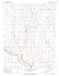
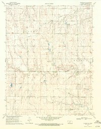 1970 Jetmore NE1971 Print · USGSWestern Hodgeman County at the start of the 1970s shows a landscape shaped by the petroleum industry and rural settlement. Researchers can trace the development of the Hanston - Oppy Oil Field or locate the local Mennonite Ch and Cem.
 - 1970 Map of Jetmore NW, 1971 Print
 1970 Jetmore NW1971 Print · USGSHodgeman County in the early seventies shows a landscape where prairie agriculture meets the petroleum boom. Researchers can trace the development of energy infrastructure through the Goebel East Oil Field, the Pawnee River valley, and several localized Drill Holes.
 - 1970 Map of Burdett, 1971 Print
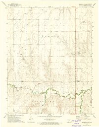
 1970 Burdett1971 Print · USGSThe rural landscape around the Pawnee River is captured here during the 1970s, showing the intersection of rail, water, and local aviation. Researchers can locate the Browns Grove Cem and trace the Atchison Topeka and Santa Fe line through Burdett.
 - 1970 Map of Horse Thief Canyon, 1971 Print
 1970 Horse Thief Canyon1971 Print · USGSHigh plains topography and remote townships define this Hodgeman County landscape in the early seventies. Researchers can trace the drainage of Buckner Creek or locate local landmarks like the Caliche Pit and Horse Thief Canyon across the townships of Hallet and Benton.
 - 1970 Map of Bazine SE, 1972 Print
 1970 Bazine SE1972 Print · USGSPawnee and Ness Counties are captured here during a peak era of petroleum production in the early seventies. Genealogists and local historians can trace the specific locations of the Schadel Oil Field, Steffen Oil Field, and landmarks like High Point.
 - 1970 Map of Ness City SW, 1972 Print
 1970 Ness City SW1972 Print · USGSNess and Hodgeman counties are captured here in the early seventies, showing a rural landscape where the energy economy meets traditional prairie life. Researchers can trace the Petersilie Oil Field and find family-history landmarks like Kunze Cem and the settlement of Harold.
 - 1970 Map of Bazine SW, 1972 Print
 1970 Bazine SW1972 Print · USGSNess and Hodgeman Counties are captured here at the height of the regional petroleum boom in the early seventies. Local researchers can trace the winding Pawnee River near Marena and locate family history at St John the Baptist Cem or Crandall Cem.
 - 1970 Map of Ness City SE, 1972 Print
 1970 Ness City SE1972 Print · USGSThe Kansas plains north of the Hodgeman county line are captured here in 1970, showing a landscape defined by the Pawnee River and the Riverside Oil Field. Researchers can locate Riverside Cem and the settlement of Riverside, while tracing local industry via several Sandpits.
 - 1972 Map of Hanston SE, 1974 Print
 1972 Hanston SE1974 Print · USGSWestern Kansas townships and drainage basins are captured here in the early seventies, showing a landscape defined by large-scale ranching and early energy development. Genealogists and researchers can trace the rural boundaries of Marena and Sterling or locate early industrial sites like the Caliche Pit and Gas Well.
 - 1972 Map of Offerle, 1974 Print
 1972 Offerle1974 Print · USGSOfferle emerges as a rail-side hub in the early 1970s, where the high plains meet the intricate drainage of Coon Creek. Researchers can locate significant burial sites like St Joseph Cem and trace the path of the Atchison Topeka and Santa Fe railroad.
 - 1972 Map of Spearville NW, 1974 Print
 1972 Spearville NW1974 Print · USGSThe high plains of western Kansas are captured here in the early 1970s, showcasing the transition from military frontier to modern energy and aviation. Researchers can trace the Fort Dodge Military Reservation Boundary and locate local landmarks like the Jetmore Municipal Airport and Saw Log Creek.
 - 1972 Map of Spearville NE, 1974 Print
 1972 Spearville NE1974 Print · USGSThe High Plains of the Kansas-Oklahoma border region are captured here in the early seventies, spanning the line between Hodgeman and Ford Counties. Researchers can locate an active Oil Field, the Jetmore Municipal Airport, and the winding course of Saw Log Creek.2 unique versions available
 - 1972 Map of Offerle NW, 1974 Print
 1972 Offerle NW1974 Print · USGSThe Kansas prairie at the boundary of Hodgeman and Ford counties shows its agricultural and industrial character in the early seventies. Genealogists can locate St Marys Ch and Old St Joseph Cem near the Atchison Topeka and Santa Fe line.
 - 1974 Map of Horse Thief Canyon SW, 1976 Print
 1974 Horse Thief Canyon SW1976 Print · USGSWestern Kansas at the height of the 1970s reveals a quiet landscape of prairie townships and resource extraction. Researchers can trace land use through a network of Gravel Pits and wells located near Sand Creek and North Roscoe.
 - 1974 Map of Horse Thief Canyon NE, 1976 Print
 1974 Horse Thief Canyon NE1976 Print · USGSHodgeman County ranching and energy extraction are on display in the mid-1970s along the winding Pawnee River. Researchers can locate the Keroma Community Hall and trace the development of the Oil Field and various Oil Well sites.
 - 1974 Map of Beeler SE, 1976 Print
 1974 Beeler SE1976 Print · USGSNess County and Hodgeman County land is captured here in the mid-seventies as petroleum development began to dot the plains. Researchers can locate the Manteno Community Hall, a local Cem, and the settlement of Monroe along the South Fork.
 - 1974 Map of Beeler SW, 1976 Print
 1974 Beeler SW1976 Print · USGSNess County and the surrounding High Plains are captured here in the mid-1970s at the meeting point of four different counties. Researchers can locate the Buda Cem and Buda Community Hall or trace drainages like Plum Creek and Hackberry Creek.
 - 1974 Map of Horse Thief Canyon NW, 1976 Print
 1974 Horse Thief Canyon NW1976 Print · USGSWestern Kansas prairie life is captured here in the mid-seventies, showing the agricultural landscape at the border of Finney and Hodgeman counties. Researchers can locate the Kitterville Community Hall and Kitterville Cem along the banks of the Pawnee River.
End of results
Showing maps 1-21 of 21
Top cities of Hodgeman County
Frequently asked questions
- What are the different types of historical maps available for Hodgeman County?
- What is the oldest map of Hodgeman County?
- Where can I purchase historical maps of Hodgeman County for my home or office?
- Where can I download high-res historical maps of Hodgeman County?
- Are there historical topographic maps available for Hodgeman County?
- Is there historical aerial imagery available for Hodgeman County?
- Where are historical maps of Hodgeman County sourced from?