1980s Maps of Kiowa County, Kansas
Explore 4 historic maps of Kiowa County from the 1980s. These maps offer a rare glimpse into what life looked like during the 1980s — showing old roads, neighborhoods, homes, and landmarks that have changed or disappeared over time.
Whether you're researching your family's past, planning a metal detecting trip, or studying how Kiowa County's landscape evolved across the 1980s, these high-resolution maps are a powerful tool for exploring the history of this region.
- Focus on a specific era: All maps on this page are from the 1980s, giving you a focused view of this time period.
- See what’s changed: Compare century-old streets, trails, and buildings to today's modern landscape using overlays and satellite layers.
- Research with precision: Use these maps for genealogy, historical research, land use analysis, or educational projects.
- View, download, or print: Maps are fully viewable online in high resolution, and can be downloaded or printed for your own records.
Start exploring Kiowa County's history through authentic maps from the 1980s. This is your window into the past.
Kiowa County, KS maps
(4)- 1980 Map of Coldwater NE
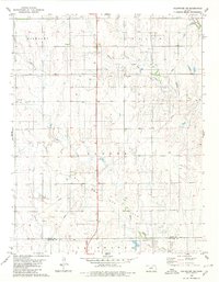 1980 Coldwater NE1980 Print · USGSThe high plains of south-central Kansas are captured here as the energy economy and old frontier lines intersect in the early 1980s. Researchers can trace the Old Indian Treaty Boundary and locate small landmarks like the settlement at Harold or several Gas Well sites.
 - 1980 Map of Iron Mountain
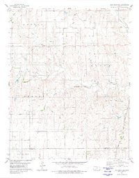 1980 Iron Mountain1980 Print · USGSThe high plains of Kiowa and Comanche Counties are captured here in the late twentieth century as energy exploration reshaped the prairie. Trace the Old Indian Treaty Boundary and explore the rail corridor of the Atchison Topeka and Santa Fe near Iron Mountain.
 - 1985 Map of Kinsley
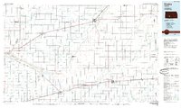 1985 Kinsley1985 Print · USGSWestern Kansas at the peak of the mid-eighties shows a landscape defined by historic treaty lines and the dominance of the rails. Genealogists and historians can trace the Old Indian Treaty Boundary and find long-standing settlements like Fort Dodge, Greensburg, and Windhorst.2 unique versions available
 - 1985 Map of Protection
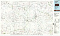 1985 Protection1985 Print · USGSThe Kansas-Oklahoma borderlands in the 1980s are defined by agricultural settlements and historical survey lines. Genealogists and historians can trace the Old Indian Treaty Boundary and locate family names near Crown Hill Cem or the town of Protection.2 unique versions available
End of results
Showing maps 1-4 of 4
Frequently asked questions
- What are the different types of historical maps available for Kiowa County?
- What is the oldest map of Kiowa County?
- Where can I purchase historical maps of Kiowa County for my home or office?
- Where can I download high-res historical maps of Kiowa County?
- Are there historical topographic maps available for Kiowa County?
- Is there historical aerial imagery available for Kiowa County?
- Where are historical maps of Kiowa County sourced from?