1980s Maps of Leavenworth County, Kansas
Explore 9 historic maps of Leavenworth County from the 1980s. These maps offer a rare glimpse into what life looked like during the 1980s — showing old roads, neighborhoods, homes, and landmarks that have changed or disappeared over time.
Whether you're researching your family's past, planning a metal detecting trip, or studying how Leavenworth County's landscape evolved across the 1980s, these high-resolution maps are a powerful tool for exploring the history of this region.
- Focus on a specific era: All maps on this page are from the 1980s, giving you a focused view of this time period.
- See what’s changed: Compare century-old streets, trails, and buildings to today's modern landscape using overlays and satellite layers.
- Research with precision: Use these maps for genealogy, historical research, land use analysis, or educational projects.
- View, download, or print: Maps are fully viewable online in high resolution, and can be downloaded or printed for your own records.
Start exploring Leavenworth County's history through authentic maps from the 1980s. This is your window into the past.
Leavenworth County, KS maps
(9)- 1983 Map of Kansas City
 1983 Kansas City1983 Print · USGSThe Missouri-Kansas borderlands reached a peak of suburban and industrial connectivity by the early eighties. Researchers can trace established neighborhoods and major landmarks like the Fort Leavenworth Military Reservation, Swope Park, and the U.S. Army Ammunition Plant.
 - 1983 Map of Olathe, 1984 Print
 1983 Olathe1984 Print · USGSThe Kansas-Missouri borderlands hum with suburban growth and historic transit routes in the early eighties. Researchers can trace the Santa Fe Trail across a landscape featuring Richards-Gebaur Air Force Base and Hillsdale Lake.
 - 1983 Map of Lawrence, 1984 Print
 1983 Lawrence1984 Print · USGSEastern Kansas in the early eighties shows a landscape of growing reservoirs and historic rail towns. Genealogists and historians can trace routes through Topeka and Ottawa, or locate smaller sites like Highland Cem and the settlement of Vassar.
 - 1984 Map of Jarbalo
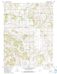 1984 Jarbalo1984 Print · USGSLeavenworth County settlements and historical demarcations are preserved here as they appeared in the early eighties. Genealogists and historians can trace the Old Indian Treaty Boundary and locate family sites near Fall Creek Cem or the community of Jarbalo.
 - 1984 Map of Leavenworth
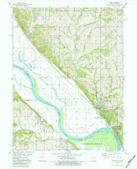
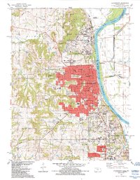 1984 Leavenworth1984 Print · USGSLeavenworth in the mid-1980s reveals a unique riverfront landscape shaped by massive government and military institutions. Genealogists and historians can trace several significant burial grounds and schools, including Mount Muncie Cemetery, Mount Zion Cem, and Immaculate High Sch.3 unique versions available
 - 1984 Map of Oak Mills
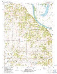 1984 Oak Mills1984 Print · USGSThe Missouri River bluffs on the Kansas-Missouri border come into sharp focus in the early eighties. Researchers can trace the Old Indian Treaty Boundary and locate numerous family-history sites like St Pats Cem and Round Prairie Ch.
 - 1984 Map of Basehor
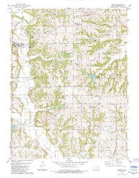
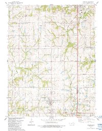 1984 Basehor1984 Print · USGSLeavenworth County in the mid-1980s reveals a landscape of growing towns and long-standing rural institutions. Trace the heritage of the region through the Old Indian Treaty Boundary, the State Penitentiary, and local landmarks like Little Stranger Cem and Hoge.
 - 1984 Map of Easton
 1984 Easton1984 Print · USGSLeavenworth County, Kansas, reveals a landscape of petroleum production and rural community life in the early 1980s. Genealogists and local historians can trace family roots at St Joseph of the Valley Ch, Springdale, and the numerous oil wells of the Easton Oil Field.
 - 1984 Map of Weston
 1984 Weston1984 Print · USGSMid-1980s Platte County comes alive along the Missouri River bends as the industrial and military landscape takes shape. Genealogists can locate family sites at Graceland Cem and Lawn Hill Cem, while historians can trace the Burlington Northern line past Iatan.
End of results
Showing maps 1-9 of 9
Top cities of Leavenworth County
- Leavenworth historical maps
- Lansing historical maps
- Fairmount historical maps
- Tonganoxie historical maps
- Basehor historical maps
- Kickapoo historical maps
See more
Frequently asked questions
- What are the different types of historical maps available for Leavenworth County?
- What is the oldest map of Leavenworth County?
- Where can I purchase historical maps of Leavenworth County for my home or office?
- Where can I download high-res historical maps of Leavenworth County?
- Are there historical topographic maps available for Leavenworth County?
- Is there historical aerial imagery available for Leavenworth County?
- Where are historical maps of Leavenworth County sourced from?