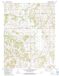
1984 Map of Jarbalo
USGS Topo · Published 1984About this map
The Old Indian Treaty Boundary cuts a diagonal line across this Leavenworth County landscape, marking a historical division in the terrain near Jarbalo. This mid-1980s survey illustrates a region defined by its watercourses and early infrastructure, where the Old Railroad Grade runs parallel to the treaty line, tracing a path through the townships of Alexandria and High Prairie. The rural character of the area is anchored by small community centers like Five Points and preserved history at Fall Creek Cem and Eagle Cem. Significant drainage systems including Stranger Creek and its tributaries, Jarbalo Creek and Rock Creek, dictate the valley patterns, while the presence of a Quarry and the Radio Tower Pumping Station reflect the local utilities and industry supporting this Kansas countryside.
Find a feature on this map
23 named features on this map. Tap any name to fly to it.
Don’t see what you’re looking for? This feature index may not catch every label — zoom into the map to look around manually.
Map Details
Editions of this 1984 Jarbalo Map
This is the sole edition of this map. No revisions or reprints were ever made.
Other maps of this area

1886 · Oskaloosa
USGS Topo · 1:125,000

1888 · Oskaloosa
USGS Topo · 1:125,000

1890 · Kansas City
USGS Topo · 1:125,000

1894 · Kansas City
USGS Topo · 1:125,000

1894 · Oskaloosa
USGS Topo · 1:125,000

1910 · Leavenworth
USGS Topo · 1:62,500

1934 · Bonner Springs
USGS Topo · 1:48,000

1940 · Bonner Springs
USGS Topo · 1:62,500

1948 · Leavenworth
USGS Topo · 1:62,500

1948 · Jarbalo
USGS Topo · 1:24,000