
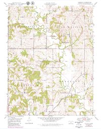
1948 Map of Jarbalo
USGS Topo · Published 1967About this map
Stranger Creek and its many winding tributaries, including Fall Creek and Jarbalo Creek, define the landscape of this rural Kansas township just after the war. The settlement of Jarbalo serves as a central hub, surrounded by a dense network of country schools that speak to the established farming communities of the late 1940s. Genealogists will find a wealth of records in the placement of Centennial School & Cem, Fall Creek Cemetery, and Eagle Cemetery. The terrain is characterized by dissected plateaus and wooded creek bottoms, with the Union Pacific line cutting through the southern portion of the quadrangle near Smith School. From the Friendship Valley School in Tonganoxie township to the Central School in the northeast, this survey documents a high density of local educational landmarks before the era of school consolidation.
Find a feature on this map
32 named features on this map. Tap any name to fly to it.
Don’t see what you’re looking for? This feature index may not catch every label — zoom into the map to look around manually.
Map Details
Editions of this 1948 Jarbalo Map
2 editions found
Other maps of this area

1886 · Oskaloosa
USGS Topo · 1:125,000

1888 · Oskaloosa
USGS Topo · 1:125,000

1890 · Kansas City
USGS Topo · 1:125,000

1894 · Kansas City
USGS Topo · 1:125,000

1894 · Oskaloosa
USGS Topo · 1:125,000

1910 · Leavenworth
USGS Topo · 1:62,500

1934 · Bonner Springs
USGS Topo · 1:48,000

1940 · Bonner Springs
USGS Topo · 1:62,500

1948 · Leavenworth
USGS Topo · 1:62,500
1949 · Basehor
USGS Topo · 1:24,000