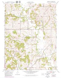
1948 Map of Jarbalo
USGS Topo · Published 1979About this map
Stranger Creek meanders through the heart of this Leavenworth County landscape, defining the topography across the townships of Alexandria, High Prairie, Tonganoxie, and Stranger. The small settlement of Jarbalo serves as a central point of interest, situated near the confluence of Jarbalo Creek and local drainage systems. The map reflects a predominantly agricultural and rural economy at mid-century, punctuated by infrastructure like the Union Pacific railroad corridor in the southeast and scattered Oil extraction sites in the west. Local history is anchored by the Fall Creek Cemetery and Eagle Cemetery, which offer valuable locations for genealogical research. The presence of Substa and the intersection at Five Points illustrate the utility and connectivity of the area's secondary road network. Numerous watercourses, including Rock Creek and Fall Creek, highlight the drainage patterns that shaped early homesteading and land use in this part of Kansas.
Find a feature on this map
20 named features on this map. Tap any name to fly to it.
Don’t see what you’re looking for? This feature index may not catch every label — zoom into the map to look around manually.
Map Details
Editions of this 1948 Jarbalo Map
2 editions found
Other maps of this area

1886 · Oskaloosa
USGS Topo · 1:125,000

1888 · Oskaloosa
USGS Topo · 1:125,000

1890 · Kansas City
USGS Topo · 1:125,000

1894 · Kansas City
USGS Topo · 1:125,000

1894 · Oskaloosa
USGS Topo · 1:125,000

1910 · Leavenworth
USGS Topo · 1:62,500

1934 · Bonner Springs
USGS Topo · 1:48,000

1940 · Bonner Springs
USGS Topo · 1:62,500

1948 · Leavenworth
USGS Topo · 1:62,500

1948 · Jarbalo
USGS Topo · 1:24,000