1960s Maps of Parker, Kansas
Explore 2 historic maps of Parker from the 1960s. These maps offer a rare glimpse into what life looked like during the 1960s — showing old roads, neighborhoods, homes, and landmarks that have changed or disappeared over time.
Whether you're researching your family's past, planning a metal detecting trip, or studying how Parker's landscape evolved across the 1960s, these high-resolution maps are a powerful tool for exploring the history of this region.
- Focus on a specific era: All maps on this page are from the 1960s, giving you a focused view of this time period.
- See what’s changed: Compare century-old streets, trails, and buildings to today's modern landscape using overlays and satellite layers.
- Research with precision: Use these maps for genealogy, historical research, land use analysis, or educational projects.
- View, download, or print: Maps are fully viewable online in high resolution, and can be downloaded or printed for your own records.
Start exploring Parker's history through authentic maps from the 1960s. This is your window into the past.
Parker, KS maps
(2)- 1961 Map of Lawrence
 1961 Lawrence1961 Print · USGSThe Kansas-Missouri borderland shows its mid-century transition from a rail-dependent agricultural region to a suburbanizing landscape. Genealogists can trace family footprints through numerous Cem sites and distinctive terrain landmarks like Graves Mound and Summers Mound.
 - 1963 Map of Parker, 1964 Print
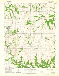 1963 Parker1964 Print · USGSMid-century Linn County comes alive in this survey, where the Missouri - Kansas - Texas railroad links the prairie towns of Parker and Goodrich. Genealogists and historians can trace local landmarks from Cadmus Sch to several rural cemeteries and the active Oil Field at the edge of town.
End of results
Showing maps 1-2 of 2
Top cities near Parker
- Paola historical maps
- Osawatomie historical maps
- Garnett historical maps
- La Cygne historical maps
- Stanton historical maps
- Mound City historical maps
See more
Frequently asked questions
- What are the different types of historical maps available for Parker?
- What is the oldest map of Parker?
- Where can I purchase historical maps of Parker for my home or office?
- Where can I download high-res historical maps of Parker?
- Are there historical topographic maps available for Parker?
- Is there historical aerial imagery available for Parker?
- Where are historical maps of Parker sourced from?