1960s Maps of Marion County, Kansas
Explore 7 historic maps of Marion County from the 1960s. These maps offer a rare glimpse into what life looked like during the 1960s — showing old roads, neighborhoods, homes, and landmarks that have changed or disappeared over time.
Whether you're researching your family's past, planning a metal detecting trip, or studying how Marion County's landscape evolved across the 1960s, these high-resolution maps are a powerful tool for exploring the history of this region.
- Focus on a specific era: All maps on this page are from the 1960s, giving you a focused view of this time period.
- See what’s changed: Compare century-old streets, trails, and buildings to today's modern landscape using overlays and satellite layers.
- Research with precision: Use these maps for genealogy, historical research, land use analysis, or educational projects.
- View, download, or print: Maps are fully viewable online in high resolution, and can be downloaded or printed for your own records.
Start exploring Marion County's history through authentic maps from the 1960s. This is your window into the past.
Marion County, KS maps
(7)- 1962 Map of Florence SE, 1963 Print
 1962 Florence SE1963 Print · USGSThe Butler and Chase County borderlands come into focus in the early sixties as a landscape of prairie drainage and agricultural sectioning. Genealogists and historians can trace the Railroad Grade and locate features like an isolated Oil Well and the Walnut River.
 - 1962 Map of Burns, 1963 Print
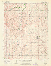
 1962 Burns1963 Print · USGSThe rural prairie of Marion and Butler Counties is captured here in the early sixties, centered on the community of Burns. Researchers can trace old family roots at Clifford Cem or locate the historic First Mennonite Ch and Ebenezer Ch among the local oil fields.
 - 1962 Map of Peabody SE, 1963 Print
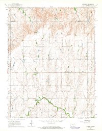
 1962 Peabody SE1963 Print · USGSThe rural borderlands of Marion and Butler Counties are captured in the early 1960s, showing a landscape shaped by the Whitewater River and oil extraction. Genealogists can locate family landmarks like Countryside Sch, Fairplay Ch, and several pioneer cemeteries.
 - 1964 Map of Ramona, 1965 Print
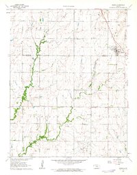
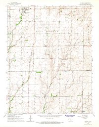
 1964 Ramona1965 Print · USGSMarion and Dickinson Counties are captured in the mid-1960s, showing a landscape defined by prairie agriculture and two major rail lines. Genealogists and local historians can locate family landmarks like Rosebank Ch, Lewis Cem, and the rural community of Ramona.3 unique versions available
 - 1964 Map of Gypsum SE, 1965 Print
 1964 Gypsum SE1965 Print · USGSThis central Kansas landscape at the dawn of the sixties shows a deep-rooted rural community where the North Cottonwood River winds through fertile plains. Genealogists can trace family footprints across numerous sites like Elm Springs, the Grand Central Sch, and Friedenstal Cem.3 unique versions available
 - 1964 Map of Tampa, 1965 Print
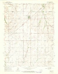
 1964 Tampa1965 Print · USGSIn the mid-1960s, the rural community of Tampa stood as a key rail point for the surrounding grain country. Genealogists can trace family footprints across several local burial grounds like College Hill Cem and St Mary Cem near the Rock Island line.4 unique versions available
 - 1965 Map of Goessel, 1966 Print
 1965 Goessel1966 Print · USGSMarion and Harvey counties appear in the mid-1960s as a structured agricultural landscape centered on the town of Goessel. Genealogists and local historians can trace rural roots through landmarks like Highland Ch, Grange Hall, and Greenfield Cem.
End of results
Showing maps 1-7 of 7
Top cities of Marion County
- Hillsboro historical maps
- Marion historical maps
- Peabody historical maps
- Florence historical maps
- Goessel historical maps
- Burns historical maps
See more
Frequently asked questions
- What are the different types of historical maps available for Marion County?
- What is the oldest map of Marion County?
- Where can I purchase historical maps of Marion County for my home or office?
- Where can I download high-res historical maps of Marion County?
- Are there historical topographic maps available for Marion County?
- Is there historical aerial imagery available for Marion County?
- Where are historical maps of Marion County sourced from?