1970s Maps of Marshall County, Kansas
Explore 3 historic maps of Marshall County from the 1970s. These maps offer a rare glimpse into what life looked like during the 1970s — showing old roads, neighborhoods, homes, and landmarks that have changed or disappeared over time.
Whether you're researching your family's past, planning a metal detecting trip, or studying how Marshall County's landscape evolved across the 1970s, these high-resolution maps are a powerful tool for exploring the history of this region.
- Focus on a specific era: All maps on this page are from the 1970s, giving you a focused view of this time period.
- See what’s changed: Compare century-old streets, trails, and buildings to today's modern landscape using overlays and satellite layers.
- Research with precision: Use these maps for genealogy, historical research, land use analysis, or educational projects.
- View, download, or print: Maps are fully viewable online in high resolution, and can be downloaded or printed for your own records.
Start exploring Marshall County's history through authentic maps from the 1970s. This is your window into the past.
Marshall County, KS maps
(3)- 1970 Map of Wymore, 1972 Print
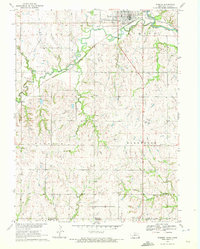 1970 Wymore1972 Print · USGSNear the Nebraska-Kansas border in the early seventies, the landscape around Wymore remains defined by the Big Blue River and its rail junctions. Researchers can trace the Old Indian Treaty Boundary and locate family plots at Wymore Cem or St Johns Cem.
 - 1970 Map of Barneston, 1972 Print
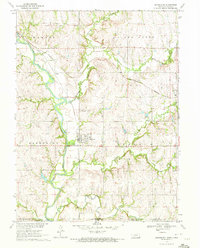 1970 Barneston1972 Print · USGSThe Nebraska-Kansas borderlands come into focus in the early 1970s as the river economy meets the rail lines. Genealogists and historians can trace the Indian Treaty Boundary, the village of Barneston, and the Liberty Cemetery along the Big Blue River.
 - 1970 Map of Odell, 1972 Print
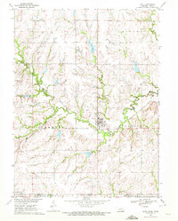 1970 Odell1972 Print · USGSOdell and the Nebraska-Kansas border lands are captured here in the early 1970s as the rail and river networks shaped local commerce. Researchers can locate specific family heritage sites like the Czech National Cem and the Old Indian Treaty Boundary.
End of results
Showing maps 1-3 of 3
Top cities of Marshall County
- Marysville historical maps
- Blue Rapids historical maps
- Frankfort historical maps
- Waterville historical maps
- Axtell historical maps
- Beattie historical maps
See more
Frequently asked questions
- What are the different types of historical maps available for Marshall County?
- What is the oldest map of Marshall County?
- Where can I purchase historical maps of Marshall County for my home or office?
- Where can I download high-res historical maps of Marshall County?
- Are there historical topographic maps available for Marshall County?
- Is there historical aerial imagery available for Marshall County?
- Where are historical maps of Marshall County sourced from?