1960s Maps of Morris County, Kansas
Explore 2 historic maps of Morris County from the 1960s. These maps offer a rare glimpse into what life looked like during the 1960s — showing old roads, neighborhoods, homes, and landmarks that have changed or disappeared over time.
Whether you're researching your family's past, planning a metal detecting trip, or studying how Morris County's landscape evolved across the 1960s, these high-resolution maps are a powerful tool for exploring the history of this region.
- Focus on a specific era: All maps on this page are from the 1960s, giving you a focused view of this time period.
- See what’s changed: Compare century-old streets, trails, and buildings to today's modern landscape using overlays and satellite layers.
- Research with precision: Use these maps for genealogy, historical research, land use analysis, or educational projects.
- View, download, or print: Maps are fully viewable online in high resolution, and can be downloaded or printed for your own records.
Start exploring Morris County's history through authentic maps from the 1960s. This is your window into the past.
Morris County, KS maps
(2)- 1964 Map of Skiddy, 1965 Print
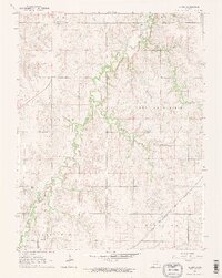 1964 Skiddy1965 Print · USGSThe rural landscapes of Morris and Geary Counties are captured in the mid-1960s, showing the settlement of Skiddy at a crossroads of rail and stream. Researchers can trace the active Chicago Rock Island and Pacific line or follow the path of an Old Railroad Grade along Clarks Creek.2 unique versions available
 - 1964 Map of Woodbine, 1966 Print
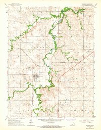 1964 Woodbine1966 Print · USGSMid-century Woodbine sits at the heart of an active rail and ranching landscape where Dickinson, Morris, and Geary counties meet. Genealogists and historians can trace the Rock Island line, find the Carry Creek Sch, and locate family plots at Woodbine Cem.
End of results
Showing maps 1-2 of 2
Top cities of Morris County
- Council Grove historical maps
- White City historical maps
- Dwight historical maps
- Wilsey historical maps
- Dunlap historical maps
- Parkerville historical maps
See more
Frequently asked questions
- What are the different types of historical maps available for Morris County?
- What is the oldest map of Morris County?
- Where can I purchase historical maps of Morris County for my home or office?
- Where can I download high-res historical maps of Morris County?
- Are there historical topographic maps available for Morris County?
- Is there historical aerial imagery available for Morris County?
- Where are historical maps of Morris County sourced from?