1970s Maps of Lenora, Kansas
Explore 2 historic maps of Lenora from the 1970s. These maps offer a rare glimpse into what life looked like during the 1970s — showing old roads, neighborhoods, homes, and landmarks that have changed or disappeared over time.
Whether you're researching your family's past, planning a metal detecting trip, or studying how Lenora's landscape evolved across the 1970s, these high-resolution maps are a powerful tool for exploring the history of this region.
- Focus on a specific era: All maps on this page are from the 1970s, giving you a focused view of this time period.
- See what’s changed: Compare century-old streets, trails, and buildings to today's modern landscape using overlays and satellite layers.
- Research with precision: Use these maps for genealogy, historical research, land use analysis, or educational projects.
- View, download, or print: Maps are fully viewable online in high resolution, and can be downloaded or printed for your own records.
Start exploring Lenora's history through authentic maps from the 1970s. This is your window into the past.
Lenora, KS maps
(2)- 1978 Map of Lenora East, 1979 Print
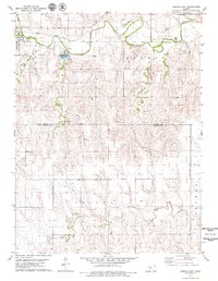 1978 Lenora East1979 Print · USGSThe high plains of northwest Kansas are captured here in the late seventies, centered on the community of Lenora and the winding North Fork Solomon River. Genealogists and local historians can locate the Modell Cem, trace the Missouri Pacific rail line, and find the County Park and Lake.
 - 1978 Map of Lenora West, 1979 Print
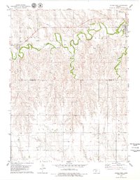 1978 Lenora West1979 Print · USGSNorthwest Kansas in the late 1970s reveals a landscape of river-valley agriculture and quiet rural crossroads. Genealogists and local historians can trace the foundations of New Almelo and Lenora, including sites like St Joseph Cem and the Quarry.
End of results
Showing maps 1-2 of 2
Top cities near Lenora
Frequently asked questions
- What are the different types of historical maps available for Lenora?
- What is the oldest map of Lenora?
- Where can I purchase historical maps of Lenora for my home or office?
- Where can I download high-res historical maps of Lenora?
- Are there historical topographic maps available for Lenora?
- Is there historical aerial imagery available for Lenora?
- Where are historical maps of Lenora sourced from?