1900s (20th Century) Maps of Lenora, Kansas
Explore 9 historic maps of Lenora from the 1900s (20th Century). These maps offer a rare glimpse into what life looked like during the 1900s — showing old roads, neighborhoods, homes, and landmarks that have changed or disappeared over time.
Whether you're researching your family's past, planning a metal detecting trip, or studying how Lenora's landscape evolved across the 1900s, these high-resolution maps are a powerful tool for exploring the history of this region.
- Focus on a specific era: All maps on this page are from the 1900s, giving you a focused view of this time period.
- See what’s changed: Compare century-old streets, trails, and buildings to today's modern landscape using overlays and satellite layers.
- Research with precision: Use these maps for genealogy, historical research, land use analysis, or educational projects.
- View, download, or print: Maps are fully viewable online in high resolution, and can be downloaded or printed for your own records.
Start exploring Lenora's history through authentic maps from the 1900s. This is your window into the past.
Lenora, KS maps
(9)- 1954 Map of Goodland, 1976 Print
 1954 Goodland1976 Print · USGSNorthwest Kansas comes into focus during the mid-1950s, showing a landscape defined by its vital river forks and thriving rail towns. Researchers can trace the path of the Union Pacific through Colby or locate historic parks like Sheridan Co State Park.
 - 1955 Map of Beloit, 1971 Print
 1955 Beloit1971 Print · USGSNorth Central Kansas in the mid-fifties shows a landscape of river-valley agriculture and expanding water infrastructure. Genealogists can trace the rail lines of the Union Pacific through towns like Nicodemus, Cawker City, and the State Sanatorium.3 unique versions available
 - 1956 Map of Goodland
 1956 Goodland1956 Print · USGSThe high plains of Northwest Kansas in the mid-fifties reveal a landscape of river-fed agriculture and expanding rail networks. Genealogists and historians can trace the development of county seats like Goodland and Atwood or locate landmarks such as the Arikaree Breaks.
 - 1957 Map of Goodland
 1957 Goodland1957 Print · USGSNorthwest Kansas in the mid-1950s shows a landscape of high plains agriculture and vital rail junctions. Researchers can trace the river-valley settlements from Goodland to Oberlin and follow the paths of the Union Pacific and Sappa Creek.2 unique versions available
 - 1959 Map of Beloit
 1959 Beloit1959 Print · USGSNorth Central Kansas at mid-century reveals a landscape shaped by river valleys and the expansion of massive water reservoirs. Genealogists and historians can trace the rail-town connections of Beloit and Norton or locate the site of the new Webster Dam.3 unique versions available
 - 1978 Map of Lenora East, 1979 Print
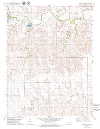 1978 Lenora East1979 Print · USGSThe high plains of northwest Kansas are captured here in the late seventies, centered on the community of Lenora and the winding North Fork Solomon River. Genealogists and local historians can locate the Modell Cem, trace the Missouri Pacific rail line, and find the County Park and Lake.
 - 1978 Map of Lenora West, 1979 Print
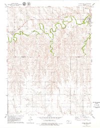 1978 Lenora West1979 Print · USGSNorthwest Kansas in the late 1970s reveals a landscape of river-valley agriculture and quiet rural crossroads. Genealogists and local historians can trace the foundations of New Almelo and Lenora, including sites like St Joseph Cem and the Quarry.
 - 1985 Map of Norton
 1985 Norton1985 Print · USGSNorth-central Kansas in the mid-1980s reveals a landscape of prairie commerce and water conservation across Norton and Phillips Counties. Researchers can trace the Burlington Northern Railroad and find local landmarks like Fairview Cemetery and the Kirwin National Wildlife Refuge.2 unique versions available
 - 1985 Map of Oberlin
 1985 Oberlin1985 Print · USGSNorthwest Kansas in the mid-eighties was a landscape of resilient prairie towns and winding creek drainages. Researchers can trace the Burlington Northern rail corridor through Jennings and Selden or locate local landmarks like the Municipal Airport and Keith Sebelius Lake.2 unique versions available
End of results
Showing maps 1-9 of 9
Top cities near Lenora
Frequently asked questions
- What are the different types of historical maps available for Lenora?
- What is the oldest map of Lenora?
- Where can I purchase historical maps of Lenora for my home or office?
- Where can I download high-res historical maps of Lenora?
- Are there historical topographic maps available for Lenora?
- Is there historical aerial imagery available for Lenora?
- Where are historical maps of Lenora sourced from?