1970s Maps of Osage County, Kansas
Explore 4 historic maps of Osage County from the 1970s. These maps offer a rare glimpse into what life looked like during the 1970s — showing old roads, neighborhoods, homes, and landmarks that have changed or disappeared over time.
Whether you're researching your family's past, planning a metal detecting trip, or studying how Osage County's landscape evolved across the 1970s, these high-resolution maps are a powerful tool for exploring the history of this region.
- Focus on a specific era: All maps on this page are from the 1970s, giving you a focused view of this time period.
- See what’s changed: Compare century-old streets, trails, and buildings to today's modern landscape using overlays and satellite layers.
- Research with precision: Use these maps for genealogy, historical research, land use analysis, or educational projects.
- View, download, or print: Maps are fully viewable online in high resolution, and can be downloaded or printed for your own records.
Start exploring Osage County's history through authentic maps from the 1970s. This is your window into the past.
Osage County, KS maps
(4)- 1971 Map of Miller, 1972 Print
 1971 Miller1972 Print · USGSOsage and Lyon counties are captured here in the early seventies, a landscape where mid-century infrastructure meets older territorial lines. Genealogists can locate family sites near Wilmington, Stotler Ch, and the Old Indian Treaty Boundary.
 - 1971 Map of Reading, 1972 Print
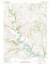 1971 Reading1972 Print · USGSLyon and Osage counties come together here in the early 1970s as the river landscape transitions near the newly formed Melvern Reservoir. Genealogists and local historians can trace family plots at Mt Calvary Cem or follow the rail corridor through Reading and Barclay.
 - 1971 Map of Osage City SE, 1972 Print
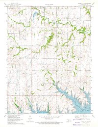 1971 Osage City SE1972 Print · USGSOsage County in the early seventies shows a landscape transformed by the rising Melvern Reservoir and the lingering tracks of the Atchison Topeka and Santa Fe. Local researchers can locate family landmarks like South Cem, the settlement of Barclay, and area Strip Mines.
 - 1971 Map of Osage City, 1972 Print
 1971 Osage City1972 Print · USGSOsage City and the surrounding townships are documented here during the early seventies, capturing the area's transition between its coal-mining roots and modern infrastructure. You can trace industrial sites like the Strip Mine and Mine Dump works or locate family plots at St Patricks Cem and the American Cemetery.
End of results
Showing maps 1-4 of 4
Top cities of Osage County
- Osage City historical maps
- Carbondale historical maps
- Lyndon historical maps
- Burlingame historical maps
- Overbrook historical maps
- Scranton historical maps
See more
Frequently asked questions
- What are the different types of historical maps available for Osage County?
- What is the oldest map of Osage County?
- Where can I purchase historical maps of Osage County for my home or office?
- Where can I download high-res historical maps of Osage County?
- Are there historical topographic maps available for Osage County?
- Is there historical aerial imagery available for Osage County?
- Where are historical maps of Osage County sourced from?