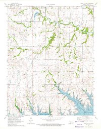
1971 Map of Osage City SE
USGS Topo · Published 1972About this map
Melvern Reservoir dominates the southern landscape of this 1971 survey, showing the rising waters of the Marais des Cygnes River valley. The map documents a transitional period for Osage County, where the industrial legacy of Strip Mines and the Atchison Topeka and Santa Fe railroad corridor meet newer recreational and water management projects. Just south of Osage City, the Osage City Reservoir and Osage City Country Club provide a snapshot of local life during the early 1970s.
Find a feature on this map
25 named features on this map. Tap any name to fly to it.
Don’t see what you’re looking for? This feature index may not catch every label — zoom into the map to look around manually.
Map Details
Editions of this 1971 Osage City SE Map
This is the sole edition of this map. No revisions or reprints were ever made.
Other maps of this area

1885 · Burlington
USGS Topo · 1:125,000

1889 · Burlingame
USGS Topo · 1:125,000

1894 · Burlingame
USGS Topo · 1:125,000

1894 · Burlington
USGS Topo · 1:125,000

1947 · Lawrence
USGS Topo · 1:250,000

1950 · Lawrence
USGS Topo · 1:250,000

1956 · Lawrence
USGS Topo · 1:250,000

1957 · Lebo
USGS Topo · 1:24,000

1957 · Waverly NW
USGS Topo · 1:24,000
1957 · Lebo NW
USGS Topo · 1:24,000