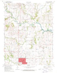
1971 Map of Osage City
USGS Topo · Published 1972About this map
Osage City serves as the industrial and civic anchor for this region of eastern Kansas during the early 1970s. The landscape is defined by the heavy footprint of the mining industry, with numerous Strip Mine sites and Mine Dump locations concentrated south of Peterton and surrounding the city center. These industrial features contrast with the historic Old Indian Treaty Boundary that bisects the central township. Transport and infrastructure are prominent, from the Atchison Topeka and Santa Fe and Missouri Pacific rail lines to the Osage City Municipal Airport.
Find a feature on this map
35 named features on this map. Tap any name to fly to it.
Don’t see what you’re looking for? This feature index may not catch every label — zoom into the map to look around manually.
Map Details
Editions of this 1971 Osage City Map
This is the sole edition of this map. No revisions or reprints were ever made.
Other maps of this area

1889 · Burlingame
USGS Topo · 1:125,000

1894 · Burlingame
USGS Topo · 1:125,000

1947 · Lawrence
USGS Topo · 1:250,000

1950 · Lawrence
USGS Topo · 1:250,000

1952 · Harveyville
USGS Topo · 1:24,000

1952 · Burlingame
USGS Topo · 1:24,000

1955 · Carbondale
USGS Topo · 1:24,000

1956 · Lawrence
USGS Topo · 1:250,000

1961 · Lawrence
USGS Topo · 1:250,000
1965 · Lyndon
USGS Topo · 1:24,000