1900s (20th Century) Maps of Hutchinson, Kansas
Explore 5 historic maps of Hutchinson from the 1900s (20th Century). These maps offer a rare glimpse into what life looked like during the 1900s — showing old roads, neighborhoods, homes, and landmarks that have changed or disappeared over time.
Whether you're researching your family's past, planning a metal detecting trip, or studying how Hutchinson's landscape evolved across the 1900s, these high-resolution maps are a powerful tool for exploring the history of this region.
- Focus on a specific era: All maps on this page are from the 1900s, giving you a focused view of this time period.
- See what’s changed: Compare century-old streets, trails, and buildings to today's modern landscape using overlays and satellite layers.
- Research with precision: Use these maps for genealogy, historical research, land use analysis, or educational projects.
- View, download, or print: Maps are fully viewable online in high resolution, and can be downloaded or printed for your own records.
Start exploring Hutchinson's history through authentic maps from the 1900s. This is your window into the past.
Hutchinson, KS maps
(5)- 1955 Map of Hutchinson, 1967 Print
 1955 Hutchinson1967 Print · USGSCentral Kansas in the mid-sixties reveals a landscape of growing reservoirs and evolving transportation corridors. Trace the development of towns like Hutchinson and Abilene alongside the Union Pacific Railroad and the expanding Interstate 70.3 unique versions available
 - 1959 Map of Hutchinson
 1959 Hutchinson1959 Print · USGSCentral Kansas thrives at the intersection of rail and river in the mid-1950s, as post-war aviation infrastructure reshapes the prairie. Genealogists and historians can trace the paths of the AT&SF RR through Newton and Hutchinson, or locate military sites like Smoky Hill Air Force Base.2 unique versions available
 - 1960 Map of Hutchinson, 1961 Print
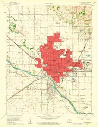 1960 Hutchinson1961 Print · USGSHutchinson and the Arkansas River valley appear in the early sixties as a bustling rail and industrial center. Researchers can trace dozens of local landmarks, including the State Fairground, the city Reformatory, and Fairlawn Cemetery.2 unique versions available
 - 1961 Map of Hutchinson SE, 1962 Print
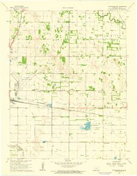 1961 Hutchinson SE1962 Print · USGSSoutheast of Hutchinson in the early sixties, the Kansas prairie was a crossroads of major rail lines and emerging aviation. Trace the vanished local footprints of Obeeville, Kent, and Punkin Center alongside the shores of Brandy Lake.2 unique versions available
 - 1985 Map of Hutchinson
 1985 Hutchinson1985 Print · USGSCentral Kansas in the mid-1980s is revealed here as a landscape of productive plains, rail corridors, and growing college towns. Genealogists and historians can trace family plots at McPherson Cemetery and follow the routes of the Missouri Pacific through settlements like Moundridge and Hesston.2 unique versions available
End of results
Showing maps 1-5 of 5
Top cities near Hutchinson
- Wichita historical maps
- South Hutchinson historical maps
- Medora historical maps
- Inman historical maps
- Buhler historical maps
- Haven historical maps
See more
Top neighborhoods of Hutchinson
Frequently asked questions
- What are the different types of historical maps available for Hutchinson?
- What is the oldest map of Hutchinson?
- Where can I purchase historical maps of Hutchinson for my home or office?
- Where can I download high-res historical maps of Hutchinson?
- Are there historical topographic maps available for Hutchinson?
- Is there historical aerial imagery available for Hutchinson?
- Where are historical maps of Hutchinson sourced from?