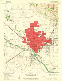
1960 Map of Hutchinson
USGS Topo · Published 1961About this map
The Arkansas River bends south of the growing city of Hutchinson, where a dense network of residential and industrial life is documented just before the 1960s. This survey illustrates a town built on both agriculture and industry, with the State Fairground anchoring the north and a significant Reformatory complex to the southeast. The rail infrastructure is particularly prominent, showing the Chicago Rock Island and Pacific and Missouri Pacific lines intersecting the urban grid. Local history is preserved through dozens of neighborhood landmarks, from the St Elizabeth Hospital to numerous educational institutions like Wiley Sch and the Jr College. Outside the city center, the landscape transitions to the specialized terrain of Salt Wells and the quiet enclave of Willowbrook, reflecting the diverse economic drivers of this Reno County hub.
Find a feature on this map
104 named features on this map. Tap any name to fly to it.
Don’t see what you’re looking for? This feature index may not catch every label — zoom into the map to look around manually.
Map Details
Editions of this 1960 Hutchinson Map
2 editions found
Other maps of this area

1889 · Cheney
USGS Topo · 1:125,000

1891 · Hutchinson
USGS Topo · 1:125,000

1891 · Cheney
USGS Topo · 1:125,000

1892 · Kingman
USGS Topo · 1:125,000

1893 · Hutchinson
USGS Topo · 1:125,000

1894 · Kingman
USGS Topo · 1:125,000

1894 · Lyons
USGS Topo · 1:125,000

1901 · Cheney
USGS Topo · 1:125,000

1955 · Wichita
USGS Topo · 1:250,000

1955 · Great Bend
USGS Topo · 1:250,000