1970s Maps of Sedgwick County, Kansas
Explore 3 historic maps of Sedgwick County from the 1970s. These maps offer a rare glimpse into what life looked like during the 1970s — showing old roads, neighborhoods, homes, and landmarks that have changed or disappeared over time.
Whether you're researching your family's past, planning a metal detecting trip, or studying how Sedgwick County's landscape evolved across the 1970s, these high-resolution maps are a powerful tool for exploring the history of this region.
- Focus on a specific era: All maps on this page are from the 1970s, giving you a focused view of this time period.
- See what’s changed: Compare century-old streets, trails, and buildings to today's modern landscape using overlays and satellite layers.
- Research with precision: Use these maps for genealogy, historical research, land use analysis, or educational projects.
- View, download, or print: Maps are fully viewable online in high resolution, and can be downloaded or printed for your own records.
Start exploring Sedgwick County's history through authentic maps from the 1970s. This is your window into the past.
Sedgwick County, KS maps
(3)- 1971 Map of Norwich, 1972 Print
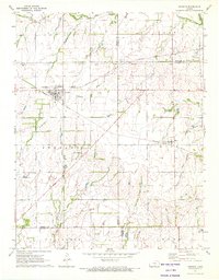 1971 Norwich1972 Print · USGSThe rural landscape around Norwich and Milton is shown here in the early 1970s, where two major rail lines intersect among the Kansas townships. Genealogists and historians can trace the Old Indian Treaty Boundary and locate family markers at Upchurch Cem or Stitch Cem.
 - 1971 Map of Millerton, 1973 Print
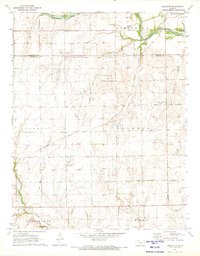 1971 Millerton1973 Print · USGSSumner County at the start of the 1970s reveals a prairie landscape shaped by historical borders and the oil industry. Genealogists and historians can trace the Old Indian Treaty Boundary or locate rural sites like Harrington Cem and Millerton.
 - 1971 Map of Conway Springs, 1973 Print
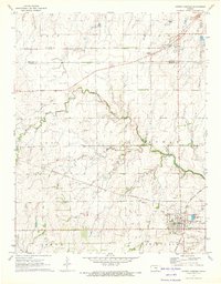 1971 Conway Springs1973 Print · USGSThe southern Kansas plains near the Sedgwick and Sumner county line are shown here in the early seventies, centered on the rail hub of Conway Springs. Researchers can trace the Old Indian Treaty Boundary and find family-history sites like St Josephs Cem and Anness.
End of results
Showing maps 1-3 of 3
Top cities of Sedgwick County
- Wichita historical maps
- Derby historical maps
- Haysville historical maps
- Park City historical maps
- Bel Aire historical maps
- Valley Center historical maps
See more
Frequently asked questions
- What are the different types of historical maps available for Sedgwick County?
- What is the oldest map of Sedgwick County?
- Where can I purchase historical maps of Sedgwick County for my home or office?
- Where can I download high-res historical maps of Sedgwick County?
- Are there historical topographic maps available for Sedgwick County?
- Is there historical aerial imagery available for Sedgwick County?
- Where are historical maps of Sedgwick County sourced from?