1900s (20th Century) Maps of Bonner Springs, Kansas
Explore 14 historic maps of Bonner Springs from the 1900s (20th Century). These maps offer a rare glimpse into what life looked like during the 1900s — showing old roads, neighborhoods, homes, and landmarks that have changed or disappeared over time.
Whether you're researching your family's past, planning a metal detecting trip, or studying how Bonner Springs's landscape evolved across the 1900s, these high-resolution maps are a powerful tool for exploring the history of this region.
- Focus on a specific era: All maps on this page are from the 1900s, giving you a focused view of this time period.
- See what’s changed: Compare century-old streets, trails, and buildings to today's modern landscape using overlays and satellite layers.
- Research with precision: Use these maps for genealogy, historical research, land use analysis, or educational projects.
- View, download, or print: Maps are fully viewable online in high resolution, and can be downloaded or printed for your own records.
Start exploring Bonner Springs's history through authentic maps from the 1900s. This is your window into the past.
Bonner Springs, KS maps
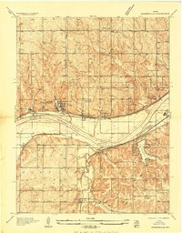
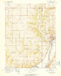
(14)- 1934 Map of Bonner Springs
 1934 Bonner Springs1934 Print · USGSLeavenworth and Wyandotte counties are shown in detail during the mid-1930s, capturing the rural landscape before post-war suburbanization. Researchers can trace family homesteads near Fairmount, Lansing, and local landmarks like Coal Ridge Sch or Hoge Sch.
 - 1934 Map of Edwardsville
 1934 Edwardsville1934 Print · USGSMid-century Wyandotte and Johnson counties are defined here by the winding river and a busy network of competing rail lines. Researchers can locate early family landmarks like St Patricks Ch, trace the settlement of Stony Point Village, or find the historic Wyandotte County Home.
 - 1940 Map of Bonner Springs
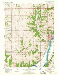
 1940 Bonner Springs1940 Print · USGSThe Kansas and Missouri rivers converge near these busy rail corridors just before the Second World War. Researchers can trace rural life through dozens of named schools like Mission Sch and the community center at Elm Grove Community Hall.3 unique versions available
 - 1950 Map of Kansas City
 1950 Kansas City1950 Print · USGSMid-century Kansas and Missouri are captured here during a period of industrial growth and shifting transportation. Genealogists and historians can trace rail lines like the Wabash RR or locate ancestral homes near the Potawatomi Indian Reservation and Horton.
 - 1950 Map of Edwardsville, 1963 Print
 1950 Edwardsville1963 Print · USGSThe Kansas River valley in the early fifties shows a bustling corridor of rail-and-river transit. Local historians can trace family roots at Edwardsville Cem or find early schools like Virginia Sch and Timmons Sch.3 unique versions available
 - 1950 Map of Bonner Springs, 1968 Print
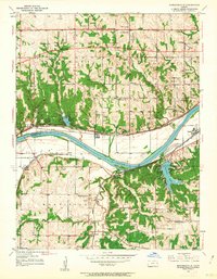
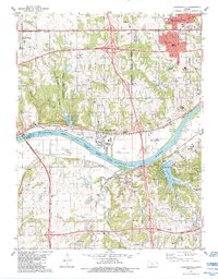
 1950 Bonner Springs1968 Print · USGSBonner Springs and the surrounding river bluffs are captured here at the start of the 1950s. Genealogists can locate family landmarks like Riverview Cem and Lenape Cem, or trace numerous local schoolhouses such as Twist Sch and Elm Grove Sch.4 unique versions available
 - 1951 Map of Edwardsville
 1951 Edwardsville1951 Print · USGSIn the early 1950s, the Kansas River valley supported a dense network of river-towns and railroads before widespread suburbanization. Genealogists can trace early homesteads and landmarks like Grinter Heights, Edwardsville Cem, and rural schools from Mission Sch to Zarah.2 unique versions available
 - 1951 Map of Bonner Springs
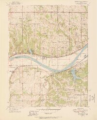
 1951 Bonner Springs1951 Print · USGSBonner Springs and the surrounding townships were hubs of activity in the early 1950s, centered on the Kansas River corridor. Genealogists and local historians can trace rural school locations like Elm Grove Sch and family burial sites at Riverview Cem or Lenape Cem.2 unique versions available
 - 1954 Map of Kansas City
 1954 Kansas City1954 Print · USGSThe Missouri-Kansas borderlands flourished in the post-war era as river commerce and rail networks converged at the Missouri River. Genealogists and historians can trace the foundations of Kansas City and smaller rural hubs like Hiawatha or Sabetha.
 - 1956 Map of Kansas City, 1967 Print
 1956 Kansas City1967 Print · USGSThe Kansas-Missouri border region thrived during the mid-fifties, centered on the growing metropolitan cores and the busy river valleys. Researchers can trace the layout of significant government sites like Fort Leavenworth and the Lake City Army Ammunition Plant.4 unique versions available
 - 1960 Map of Kansas City
 1960 Kansas City1960 Print · USGSMid-century Kansas and Missouri meet at the river forks, showing a sprawling rail-and-river economy during the 1950s growth era. Genealogists and researchers can trace tribal lands like the Kickapoo Indian Reservation or follow the early interstate corridors through Saint Joseph and Independence.3 unique versions available
 - 1983 Map of Kansas City
 1983 Kansas City1983 Print · USGSThe Missouri-Kansas borderlands reached a peak of suburban and industrial connectivity by the early eighties. Researchers can trace established neighborhoods and major landmarks like the Fort Leavenworth Military Reservation, Swope Park, and the U.S. Army Ammunition Plant.
 - 1984 Map of Edwardsville
 1984 Edwardsville1984 Print · USGSThe Kansas River valley comes into focus during the early 1980s, documenting the industrial and residential growth across Wyandotte and Johnson counties. Researchers can trace local history through the Agriculture Hall of Fame, rural schools like Huyett School, and rail stops at Holliday and Wilder.
 - 1991 Map of Edwardsville, 1996 Print
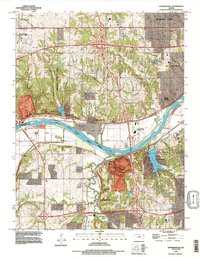 1991 Edwardsville1996 Print · USGSIn the early 1990s, the river valley west of Kansas City shows a transition from industrial hubs to suburban neighborhoods. Researchers can trace historic settlements like Edwardsville, Holliday, and Zarah alongside landmarks such as Quivira Lake and the County Fairgrounds.
End of results
Showing maps 1-14 of 14
Top cities near Bonner Springs
- Kansas City historical maps
- Overland Park historical maps
- Kansas City historical maps
- Olathe historical maps
- Shawnee historical maps
- Lenexa historical maps
See more
Top neighborhoods of Bonner Springs
Frequently asked questions
- What are the different types of historical maps available for Bonner Springs?
- What is the oldest map of Bonner Springs?
- Where can I purchase historical maps of Bonner Springs for my home or office?
- Where can I download high-res historical maps of Bonner Springs?
- Are there historical topographic maps available for Bonner Springs?
- Is there historical aerial imagery available for Bonner Springs?
- Where are historical maps of Bonner Springs sourced from?