1900s (20th Century) Maps of Cedar Springs, Kentucky
Explore 6 historic maps of Cedar Springs from the 1900s (20th Century). These maps offer a rare glimpse into what life looked like during the 1900s — showing old roads, neighborhoods, homes, and landmarks that have changed or disappeared over time.
Whether you're researching your family's past, planning a metal detecting trip, or studying how Cedar Springs's landscape evolved across the 1900s, these high-resolution maps are a powerful tool for exploring the history of this region.
- Focus on a specific era: All maps on this page are from the 1900s, giving you a focused view of this time period.
- See what’s changed: Compare century-old streets, trails, and buildings to today's modern landscape using overlays and satellite layers.
- Research with precision: Use these maps for genealogy, historical research, land use analysis, or educational projects.
- View, download, or print: Maps are fully viewable online in high resolution, and can be downloaded or printed for your own records.
Start exploring Cedar Springs's history through authentic maps from the 1900s. This is your window into the past.
Cedar Springs, KY maps
(6)- 1926 Map of Scottsville
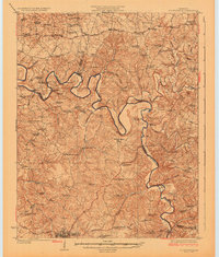 1926 Scottsville1926 Print · USGSThe Barren River valley in the mid-twenties was a landscape of ferries and fords connecting isolated rural schools and churches. Researchers can trace ancestral locations like Scottsville, find the Rocky Hill Game PO, or locate the Rough and Ready School.
 - 1954 Map of Austin, 1955 Print
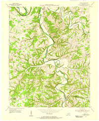 1954 Austin1955 Print · USGSThe Barren River hills of rural Kentucky come to life in the mid-1950s, showing a landscape defined by sharp river bends and scattered ridge-top farms. Genealogists can locate old family landmarks like Browns Ford, Pleasant Home Ch, and the Old Austin-Tracy High Sch before modern changes transformed the region.
 - 1956 Map of Nashville, 1971 Print
 1956 Nashville1971 Print · USGSThe Tennessee-Kentucky borderlands come into focus in the mid-1960s as major reservoir projects transformed the Cumberland and Tennessee river valleys. Researchers can trace the rail networks of the Louisville and Nashville and visit sites like Fort Campbell and Fort Donelson National Military Park.2 unique versions available
 - 1959 Map of Nashville
 1959 Nashville1959 Print · USGSMiddle Tennessee and Southern Kentucky come into focus during the late fifties, showing the region's transition into a modern transportation and military hub. Researchers can trace the sprawling Fort Campbell Military Reservation or locate historic rail stops along the Tennessee Central Ry and Illinois Central RR.
 - 1965 Map of Austin, 1967 Print
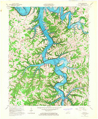 1965 Austin1967 Print · USGSBarren and Allen Counties are shown in the mid-1960s as the rising waters of the Barren River Reservoir reshaped the valley. Genealogists and local historians can trace family locations near Austin, Cedar Cross Cem, and Capitol Hill Ch.4 unique versions available
 - 1985 Map of Bowling Green
 1985 Bowling Green1985 Print · USGSThe rolling borderlands of Kentucky and Tennessee are captured here in the mid-eighties, showing a landscape shaped by the Barren River and deep-rooted rail networks. Genealogists and researchers can trace local landmarks like Prices Mill, Highland Academy, and Green Lawn Cem.3 unique versions available
End of results
Showing maps 1-6 of 6
Top cities near Cedar Springs
- Bowling Green historical maps
- Glasgow historical maps
- Scottsville historical maps
- Smiths Grove historical maps
- Oakland historical maps
- Fountain Run historical maps
Frequently asked questions
- What are the different types of historical maps available for Cedar Springs?
- What is the oldest map of Cedar Springs?
- Where can I purchase historical maps of Cedar Springs for my home or office?
- Where can I download high-res historical maps of Cedar Springs?
- Are there historical topographic maps available for Cedar Springs?
- Is there historical aerial imagery available for Cedar Springs?
- Where are historical maps of Cedar Springs sourced from?